Tag Archives: severe weather

May 10, 2017: Funnel Cloud in Southeast Colorado

IMG_9723.jpg

May 10th was kind of a strange storm chasing day for me.  It was the kind of day that calls into questions a whole bunch of things for me.  What assumptions I make.  How I go about making decisions.  Both with regards to where and when to chase, as well as about life in a broader sense.

There are so many things that end up factoring into when and where people chose to chase severe thunderstorms.  I had chosen to go on this two-day chase (see day one) partially out of frustration I was experiencing back home.  It was one of those situations where I felt like it would just be good for me to do something I had not done in a while, for a change of pace, and I had yet to chase in 2017.

So, I went to chase on a Tuesday and Wednesday with only a slight risk for both days, something many people with jobs tend not to do, particularly when the outlook shifts so far away from home on the second day.

In fact, I was not even sold on chasing again on Wednesday, as leftover storms from Tuesday would prevent the area that I had originally thought would have the best dynamic setup for storms from developing the instability needed to fuel them.

I decided to stay out partially because of the more optimistic outlook from the Storm Prediction Center, and partially because I got an email from a friend, telling me he was excited about the outlook… in Southeast Colorado.

Still, I decided originally to target Southwest Kansas.  Given the outlook, the best place to be would have been well further south, at least into the Texas panhandle.  But, you know, those life considerations.  I did want to make it back to Denver that evening.

IMG_9657.jpg

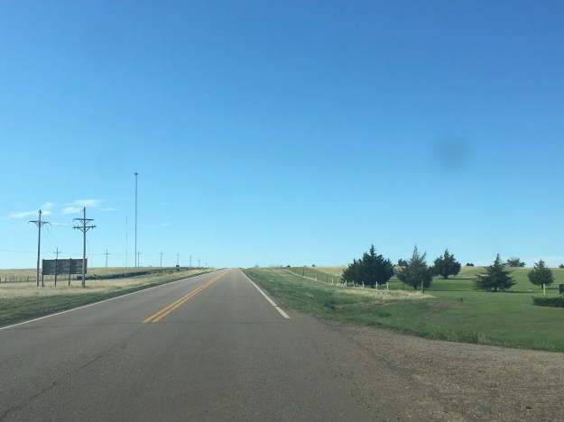
Whenever in Western Kansas, I always kind of think the same thing.  This place is flat, but it is not as flat as Florida, or Northern Illinois.  People often assume the place is flat.  But, according to a study in National Geographic, Kansas is not even in the top 5 flattest states.

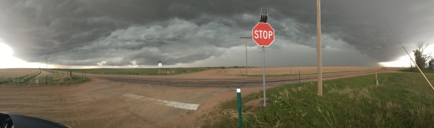
One aspect of storm chasing that is often missed by people watching storm videos, or the movie Twister, is the fact that storm chasing involves a lot of driving, and it also often involves a lot of waiting.  On many days, chasers pick a “target” location, where they believe storms are likely to form, and sit there, sometimes for hours, waiting for them to form.  Because it was unrealistic to get down to the Texas Panhandle and still get back to Denver in the evening, we chose to sit in a town called Ulysses, Kansas because my favorite weather website had analyzed another boundary near there.

Ulysses, by the way, was named after Ulysses S. Grant, Civil War general and 18th President of the United States.  Why a place like this cares so much about this historical figure from Galena, Illinois confuses me a bit.  But, at least the town had highways in all four cardinal directions, and an empty field with a cell tower, so we could look at weather information while we wait.

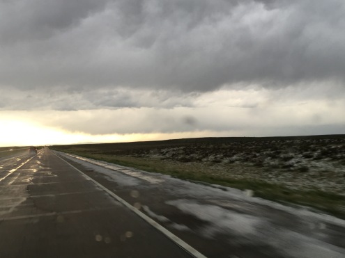
And, this requires patience, and continued belief that the right location had been chosen.   But, May 10th was not a typical day.  Storms started to form in this region, first just clouds, and then even some small thunderstorms.  I was even proud to have seen a storm  start to produce rain before the RADAR images even began to reflect it!

IMG_9693

Now, that’s what I call “catching initiation”.

The problem is, we caught the wrong initiation.  These storms would never amount to anything.  In fact, they were so small that when I zoomed out on a RADAR image, they were barely visible!

IMG_9701

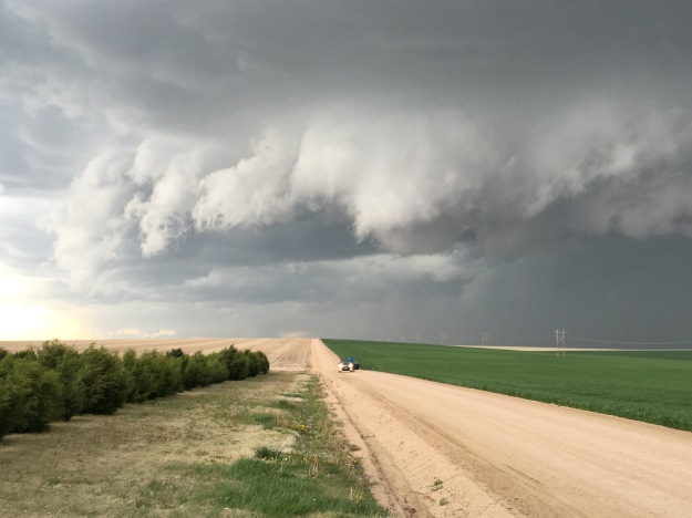
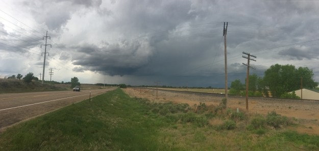
It turned out that, despite the fact that some of the sites I typically look at for weather information indicated some potential, we were in “no man’s land”.  The boundary I thought was situated near the CO/KS border was actually farther West, and storms were forming … in Southeast Colorado.  So, we had to adjust, headed back into “Colorful Colorado” (although today it would be “Colorful” for different reasons).

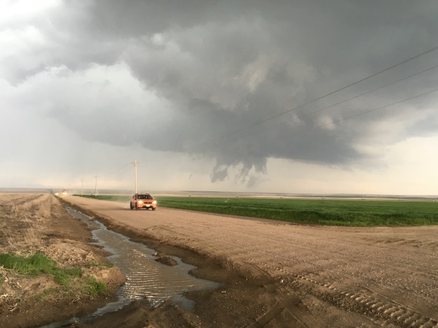
It was there we saw the main feature of the day, a funnel cloud near the town of Lamar, CO.

IMG_9722.jpg

For a while it looked like it was rotating and trying to form a tornado, but from experience I know that in Eastern Colorado only 1 in 8 of these actually turn into tornadoes.

The entire day was kind of a head scratcher.  What did my friend see that I didn’t?  What did he see that SPC kind of didn’t?  Why did so many storms form north and west of where the outlook was?

Why did my the information sources I typically point to lead me kind of to the wrong place?

I also wonder if I was chasing the right way, and for the right reasons.  The weather bends to nobody’s schedule.  The weather doesn’t care about personal preferences, conveniences, one’s life situation, or ego.  We have tools that provide good guidance into what is going to occur.  And, those tools pointed to a clear spot that they were correct about, as the biggest cluster of tornado producing storms of the day formed in Northwest Texas, near Childress, crossed into Southwest Oklahoma, and produced tornadoes.  That just didn’t fit into my plan.

The chase ended up turning into somewhat of a metaphor, for life decisions in general.  When we chose to take part in an activity, of any kind, we get the most out of it when we are willing to go “all in” per say.  This is true of jobs, hobbies, relationships, you name it.  We have to be willing to adjust, and consider a whole bunch of circumstances and other factors.  But, sitting in the middle, waiting for two or more different opportunities to possibly manifest only works well for a little while.  In the end, a choice needs to be made, and even if it is not the ideal choice, the fact that a choice was made produced a better outcome than having allowed the entire day to lapse without making one at all.

Lessons Learned?

IMG_5847

Some events in life are clear.  They can be clearly labeled a success or a failure.  The reason for the success or failure is clear, and there is a clear lesson to be learned from it.  One comes out of an event of this nature much like an idealized application of the scientific method.  A piece of new information is obtained.  It either strengthens a pre-existing theory or calls it into question.

In the real world is not ideal like that.  Many observations, an many of our life experiences do not even produce a clear cut data point, a clear “success” or “failure”, or a clear lesson to be learned.  This was certainly the case on my first storm chase of the 2016 severe storm season, on Saturday, May 7th.

It was a day that did not require me to travel far to chase.  In fact, I returned home to Denver less than eight hours after departure, something that cannot typically be expected.  If I lived in a City right in the heart of “tornado alley”, such as Oklahoma City, Topeka, or Lincoln, I would expect to be able to regularly see great storms without having to allocate an entire day.  However, Denver is a bit West of the region most prone to severe thunderstorms, much the same way Chicago is a bit East of that region.  When I moved to Denver, I did have to make some adjustment with regards to storm chasing, but I did not significantly alter my expectations regarding time spent or distance traveled on a typical one-day storm chase.

Saturday’s severe storm setup provided me with a somewhat familiar dilemma, and one that is even more common chasing storms in Colorado, where many thunderstorms are initiated by orographic features.  Severe storms need a certain environment to thrive, one that is warm an moist, but also with some kind of boundary to create low-level wind sheer, which creates the rotation necessary for supercells, and tornadoes, to form.

Saturday was not that kind of day in the Denver metropolitan area. The Denver area spent the entire day in a thick field of low level cloudiness that prevented the air from warming up.  The high temperature at Denver International Airport was only 53.  Ideal conditions were farther East.  That day the high in Fort Morgan, close to where a lot of the violent storms would hit, was 68.  As is the case with any storm chase, it is important to get into an area where the environment will be favorable for storm development.  So we drove East of the cloud deck.

IMG_5826

But then it happened, forced by the Palmer Divide, thunderstorms formed just to the North and East of Colorado Springs, in an area where conditions were not favorable for severe storms.  Sitting in Byers, roughly 40 miles East of Denver, we had a choice; do we go South and West to catch the storm now, or do we hang back and wait for the storm to reach our current location, in a more favorable environment?

Staying back means potentially missing what the storm does in its early phases.  However, being more aggressive means possibly missing a different storm, that may form in an area with better conditions for severe storms.  On Saturday, after some deliberation, we decided to go after the first storm.  We felt cold air, possibly the coldest I have ever been in while observing a thunderstorm, and saw a strong downdraft.  This is consistent with an atmosphere that is cooler and drier than the ideal one for producing severe weather.

IMG_5831.jpg

The storm raced northward.  We ended up being a little bit limited by the relatively sparse road network in Northeastern Colorado, having to follow the storm along a series of dirt roads that connected Strasburg, CO (along I-70), to Wiggins, CO (which is along I-76).

IMG_5836.jpg

In fact, there was even a time when we were pretty much directly under where the RADAR echoes showed the center of circulation to be.  This situation sort of made me nervous.  At the time I was thinking that if a tornado were to form, it might form quite close to my current location.

IMG_5837.jpg

For roughly an hour, it seemed like the storm was kind of teasing us.  One minute, these clouds would appear to be lowering and rotating, as if a tornado were ready to form, the next minute it would all just simply disappear.

IMG_5839

It was around this time that the storm reached I-76 near Wiggings.  Here, the storm interacted with a previously existing boundary, and, according to sources, went tornadic.  However, we were never able to observe the tornado.

After this, the storm transitioned, as many severe storm clusters often do, into a large bow echo.

This is a clear indicator that the storm is entering a different phase, often associated with decay.  It has become dominated by downdrafts.  The most likely result is severe straight line winds.  At this point in time, the best thing to do is simply observe this gigantic thunderstorm, as despite no longer having the low-level rotation necessary for tornado formation, it is quite breathtaking in its own way.

Storm chasing, and storm observation is about more than just tornadoes, and it is quite unfair to describe all chases that do not result in viewing a tornado as a “failure”.  We really could not have picked a better place.  There was only one other cluster of storms that day that produced numerous severe storm reports.  That one formed farther East, a bit later, and produced tornadoes when it interacted with the same East-West oriented boundary.  We also still observed some interesting severe convective storms.

But still, it is frustrating to know that there was indeed a tornado, verified, within ten miles of where I was sitting, and I somehow did not get to actually see it.

I know being in position to view this storm was quite challenging, and it is likely that few chasers found themselves in such position to view the tornado.  But I wonder, had my group reached the I-76 corridor 15-20 minutes earlier, would we have been in the right position to see it?  We knew this boundary was there, and it was in the area with the most ideal conditions.  Was going after the storm initially an exercise in impatience?

IMG_5851.jpg

The day ended with a return trip, along I-76, back to Denver, through the area that was clearly just recently pelted with hail.  I returned knowing that there are aspects of this chase that can be considered a “success”, but others that can be considered a “failure”.  I also returned still wondering how to strike that proper balance between aggressively chasing after storms that initiate, and patiently waiting for storms to form or reach the location where the conditions appear to be most favorable.