Category Archives: hiking

Wisconsin’s Northernmost Region

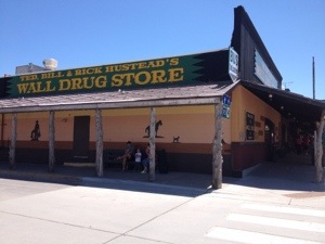
Yesterday I returned to a place I had been to only once before. The town of Bayfield, WI is along Wisconsin’s Lake Superior shoreline, and despite being a very small town (population less than 500), it is popular in the summer, as it is linked to the Apostle Islands, which is an island chain in Lake Superior with some unique scenery. Due to the geography of Wisconsin, this is the northernmost part of the state. It is the only part of the Lake Superior shoreline in Wisconsin, as farther east, the shoreline hits the Upper Peninsula of Michigan. This part of the state is actually over 300 miles from both Milwaukee and Madison, making it quite different than the part of the state I am most familiar with. In fact, someone once told me that sometime in the 1970s there was talk of this part of Wisconsin joining with the U.P. of Michigan to form a new state, breaking away from their respective states due to serious cultural differences.

The first time I came here, in 2007, I was kind of obsessed with waterfalls. So, I found a place called Copper Falls State Park, which has some pretty nice falls. This particular trip warranted a return trip to Copper Falls, as some of the others on this trip live in Chicago, where there is little opportunity to find good waterfalls.

20130614-164212.jpg

The trail system at this state park is actually part of a larger trail system called the North Country National Scenic Trail. This trail system is only partially complete, but they eventually hope to connect central North Dakota all the way to upstate New York via a trail that follows some of the northernmost parts of the country. I am guessing they are hoping for it to be like the Appalachian Trail, but it seems like they are still a long way from completing this trail, and even when it’s completed it will be nowhere near as scenic as the Appalachian Trail, or the Great Divide or Colorado Trail for that matter.

20130614-164702.jpg

20130614-164710.jpg

20130614-164718.jpg

20130614-164723.jpg

20130614-165947.jpg

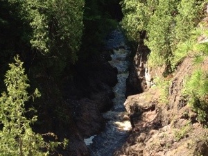
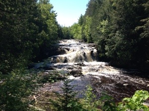
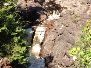
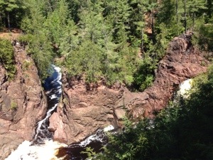
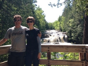
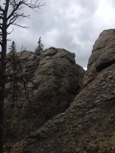
The hiking here was pretty easy, especially when compared with some of the hikes I have been doing more recently, with the move to Colorado and the trip to South Dakota. However, they did have some decent waterfalls in several different places. They are called the “Copper Falls”, due to their coloring, which actually comes from the type of red clay present in the region. As far as I know, the region has nothing to do with the mineral copper, and nor does the name of this particular waterfall.

20130614-165142.jpg

20130614-165147.jpg

Having lived in Colorado for some time now, a few things about this hike seemed quite different than what I am now used to. First of all, the hike felt to me like a luxury hike compared with what I have been doing more recently. There were some areas where staircases had been built, and there was even a sheltered bench built for resting. This is not something I have come to expect on a hiking trail. I had become accustomed to simply using a good rock or log to rest on if I were to get tired.

It was also way more wooded here than what I had become accustomed to. I guess they call it the “north woods” for a reason. It was so wooded here that I did not suffer any consequence for forgetting to wear sunscreen. At the end of the hike, I was actually way more anxious to put on bug spray. Parts of this hike had an excessively large concentration of mosquitoes. I think I killed like 50 of them and still got a bunch of bites. I cannot even seem to recall the last time I was in such a mosquito infested area.

20130614-170515.jpg

20130614-170130.jpg

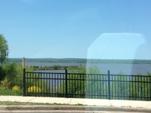
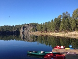
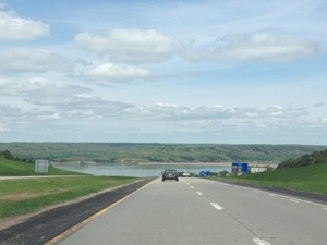
After hiking Copper Falls, we drove up to Bayfield, the town most closely associated with the Apostle Islands. This is because the ferries that run to the islands all run out of this town. On the way up there, we hit the Lake Superior shore, and subsequently the Lake Superior circle tour, which is a series of roads that a motorist could follow around the lake. When I lived in Chicago, I recall being along and seeing signs for the Lake Michigan circle tour from time to time. In fact, that tour follows Lake Shore Drive in the city. The signs are neat, but taking the two or so days to drive around the lake seems like a strange idea to me.

20130614-170754.jpg

20130614-170800.jpg

20130614-170805.jpg

We took a ferry to Madeline Island, which is the largest island in the chain. In fact, it is the only island with roads. The others are largely uninhabited, but people still take boats, kayaks, etc., and camp and hike there. We did not end up spending too much time on Madeline Island. There wasn’t too much to do there, at least not for us. They do have a golf course, some beaches and trails, but it seemed to me that most things available on the island are also available in Bayfield, and in other areas on the mainland. Maybe it is still not quite peak tourist season yet.

I did enjoy the ferry ride. It actually brought back some distant memories for me. When I was a kid, growing up on Long Island, my family would periodically take trips that would involve bringing our car on the Orient Point ferry to Connecticut. This ferry ride was not nearly as long, and on fresh water instead of salt water, but driving onto the ferry and walking up the stairs did bring back those memories a couple of decades later. It is strange how, after all those years, the feelings can still be the same. The people with me probably thought my behavior at this point in time was a bit odd, as I was doing and saying certain things out of some kind of long dormant reflex that likely made little sense in the context of where we were. I even stated to crave seafood. It was somewhat of an odd feeling, but a good one.

Hiking in the Black Hills

June 4, 2013

Mount Harney is the tallest peak in South Dakota. In fact, it is the tallest peak anywhere east of the Rocky Mountains. The guy at the Custer State Park visitors center actually said it was the “Tallest peak between the Rockies and the Alps”. While that is technically true, it is a bit of a stretch. At 7242 ft., it is taller than anything in Appalachia, including the tallest peaks in the Smoky Mountains, but not really by too much. The difference is less than 1000 ft., and is probably made up for by the fact that the bases of those mountains are at lower levels.

However, it was still a really good hike. In fact, it kind of reminded me of hiking near Boulder a bit. It is at similar elevations, a similar total climb, and there are some major rock formations here too. Our loop from Sylvan Lake up to Harney Peak and around by two other major features; Little Devil’s Tower, and the Cathedral Spires, took us a bit over 8 miles today. With what is probably close to 2000 ft. of vertical climbing, between the main climb and a couple of side climbs, it was a very satisfying hike. With this morning’s drive taking us by the ” Needles Eye”, we have actually seen nearly half of the unique natural features of South Dakota. Not bad considering that we only arrived in South Dakota on Sunday.

20130606-152731.jpg

20130606-152744.jpg

At the top of Harney Peak there was a strange lookout point. It was actually the remnants of an old building. We think people actually hid out here, but I am not sure who. It was still interesting to see the place, and imagine the life of someone living on top of the tallest peak in the area. From this vantage point, you can see all of the peaks. We could look out on all of the peaks of the Black Hills, including the ones we had driven up and down yesterday and today, and they all showed up significantly below us. This may be the first time I have experienced this exact feeling, climbing my own way up to the top of the highest peak in the area. In 2005, I biked up Blue Mounds (Wisconsin), but the terrain there is nothing compared to what it is here. In 1998, my family and I drove up Pike’s Peak, but, we drove.

20130606-152544.jpg

20130606-152552.jpg

The alternate trail we took on the return trip to the car took us real close to the Cathedral Spires. These rock formations remind me of the Dolomites in Northern Italy, with their mostly vertical, but imperfect, gray colored rock structures of varying heights. In fact, for the entirety of the hike, as well as in many cases before and after, I have been referring to this feature as “The Dolomites”. And, no, I am not trying to show off that I am Italian, or that I have been to Italy. It is just kind of natural for people to make the association in their head based on the visual. I am reminded of an instance when someone I knew kept referring to the green sauce that they provide with samosa at an Indian restaurant as guacamole. He was not trying to show off his Mexican-ness, it was just that his previous experiences with green sauces in restaurants had mainly been guacamole, and the natural association was made. In the same vein, the other time. I had seen rock formations like that, it was the Dolomites. Some of the other rock formations did look like the Flatirons in Boulder, with a major exception being that they are lighter in color.

20130606-152834.jpg

20130606-152849.jpg

On this hike, in several places, both on and off the trails we were traversing, we passed through some tight areas inside rock formations. This was a good deal of fun, although somewhat scary. Oddly enough, I enjoy doing things like this, and I have not even completely figured out why. I guess there is a slight element of danger in it, and it does provide the hike with some variety. But, hiking is already an interesting enough activity that it does not need variety. And, I am not really pushing my limits anymore with this nonsense, as I have done it plenty of times over the past several years. Maybe it is just curiosity, the entrance into the unknown, the feeling you get when anything can happen. In this sense, it would be the same feeling that drives people to take a new route home, enter into new activities and new social circles, or even drink or do drugs. The flirtation with the unknown seems to come out in me a lot; skiing, hiking, parties, etc.

One final note about the hike. Boy have these pine beetles done a number on the forrest here. Scenes like this one are seen everywhere, and when viewed at a distance, parts of the “Black Hills” look quite red! I knew this was a big problem in Colorado, but it actually seems like the beetles have done even worse to the forests here. It is sad to think that the very nature of these places are bound to change forever, but in life, change is inevitable. It cannot be avoided at any costs.

20130606-152926.jpg

Our other activity today was visiting Crazy Horse. Crazy Horse is a statue of a famous Native American hero that sits on the other side of the black hills from Mount Rushmore. But, it is incomplete. It has actually been under construction since 1948, and is still nowhere near close to done. According to the hosts at our campground last night, the Crazy Horse statue will “not be completed in your grandchildren’s lifetime”. This slow progress is due to the desire to make this statue quite enormous, as well as their commitment to use only private funds. Turning down money shows a significant amount of pride, and/ or adherence to principles. Maybe both, they are actually probably quite related.

20130606-152949.jpg

20130606-153001.jpg

At Crazy Horse is also a museum of the Native American. We did not intend to spend all day there, so I pick a few excerpts to read, some about famous Native Americans. I don’t even remember the stories themselves, but reading these stories makes me more curious about Native American culture in general. History is written by the winners, and in the battle for North America, we, the white man, are the winners. But, it is hard to ignore the fact that we kept making and then Subsequently breaking treaty after treaty with these Native tribes. I would love to know the full story behind this, from both perspectives, and how the modern day Native Americans feel about all this, as well as the situation they are in now. Are they happy to have all the modern conveniences associated with the U.S.A.? Do they feel that we are the ones protecting the freedom of all? Or do they feel they cannot live the lifestyle of their choosing, and their continent has been usurped? I bet you get some real mixed emotions.

On the campground tonight, we got a bit goofy. In fact, we spent probably about half an hour, sometime around sunset, trying to throw pine cones into the campfire from various places. Most of them were from the top of a rock. It was some unexpected (and free) fun. I think our society could use a bit more of that if you ask me. One of my favorite things about trips like this are actually simple things like this that bring joy out of nowhere, unexpectedly.

20130606-153140.jpg

Experiencing Western South Dakota

June 3, 2013

Today’s first activity was a hike at Badlands National Park. Yesterday evening, at the visitors center, I had chosen a hike for our group that was mostly considered “moderate”. Only the initial 1/4 of a mile, which started from the parking lot and took us up the side of the structures towards a plateau was considered “strenuous”. This initial part was pretty strenuous, and, had it gone on for over a mile, would have made a difficult hike. But, after the initial climb, most of the trail system we traversed on this morning, would be pretty flat, with only minor inclines and declines. This, of course, was the part of the trail that was labelled “moderate” in difficulty. I guess, the “moderate” difficulty rating was a let down because, the badlands, while a beautiful natural place, is not a place with a lot of terrain. There simply isn’t 1,000 ft. worth of incline to find.

20130605-211914.jpg

20130605-211920.jpg

Difficulty ratings for hikes have no set standard. How any place labels it’s hikes is completely to the discretion of the park. It reminds me of the differences we observe between ski trails labeled green vs. blue vs. black at different ski resorts. Some of the easiest black diamond ski trails I have skied in Wisconsin may even be considered green if they were to be in Colorado; certainly, they would at least be blue, not black. So, I guess it is important to understand the relative context of activities while planning them. While occasionally you will run into an activity with a standardization of sorts, like whitewater rafting, it seems like when it comes to most activities, descriptions of difficulty levels are subjective as well as relative.

The biggest waste of time today was driving about five miles out of our way to search for Bison at the Badlands. The reason being that our ultimate destination today was Custer. In Custer we saw so many Bison, and so many up close, that the search for Bison anywhere else today, well, the idea of looking for Bison anywhere else today seems utterly silly at this point in time.

20130605-212020.jpg

20130605-212029.jpg

We gave in to the nearly 200 (well, possibly even more) billboards we saw yesterday, and we went to Wall Drug. This place does a really good job of marketing itself, given that the main goal of marketing is to make people aware of your product. The signs, bumper stickers, and such make sure everyone is aware of the existence of Wall Drug. I had heard from others that the place was a gigantic tourist trap and not really worth it, but it is so close that it is worth going and finding out for myself.

20130605-212113.jpg

20130605-212119.jpg

The place was actually alright. It was a little bit cheesy. In the front , there is an actual drug store, true to its name. Behind that is a restaurant and ice cream parlor, which is pretty neat. The rest is mainly souvenir shops. Behind the store, there is this kind of old west town that many tourist traps in the high plains have. The only oddity is that they also have a really poor replica of a dinosaur there too. This was advertised on many billboards, so I am glad the delivered on this. But this does not belong right next to a replica of a village from 1880. Time periods should be consistent.

I made one key mistake there. I ate both ice cream and a donut. That is just simply too much sugar, simple sugar. A little over half an hour down the road, I got that sugar crash, and, for about half an hour could barely keep myself awake. This sucked, because the scenery was starting to become really interesting as we approached Rapid City and then drove Southwest on U.S. 16, and the 16-A.

20130605-212203.jpg

20130605-212213.jpg

The mountains here (I guess they are referred to as hills), are legit. I mean, the way the look, both from a distance, and up close when you drive into them, are actually not too different from the mountains of Colorado. This, I find somewhat surprising. When people make lists of states with really cool mountains, and I mean really big ones, it does not seem like South Dakota is ever really on that list. At least the association is never really made in my mind. I had always kind of known South Dakota to be kind of more interesting than the other plains states, and known that this area existed. But, it was not until now that I fully realized that the terrain in this area is significant when compared to other places in the country. It’s not as mountainous as Colorado, but it is not insignificant.

20130605-212245.jpg

20130605-212250.jpg

20130605-212301.jpg

20130605-212310.jpg

Today the sun rose at 5:30, and set at 8:30, for a total of 15 hours of daylight. I kept thinking about how much is possible with all these hours of daylight. It takes generally an hour or so to set up camp, start a fire, and cook. Today, we were able to take showers because we had extra time after cooking. This was after not arriving until nearly 6:00. In most other months, this would not have been possible. All this week, it seems like we had been less stressed, or had gotten more done than we would have in the fall, or some other time of year with less sunlight.

The problem is, June is the best time of year for a lot of things. Storm chasing is good, rafting is good, and with the most daylight possible, camping, touring, and such are all easier. So, how do we take advantage of our Junes. Should we work our asses off at other times of the year so we could get June off? That might cause too much stress at the other end of the year. How do we decide what activities are most deserving of these days? At the very least, the NBA and NHL can stop extending their playoffs into June so people don’t use up this time watching sports.

Oh, and we also saw Mount Rushmore. It was a bit smaller than I expected.

Camping in the Badlands

Today, June 2nd, started with a bang. Following our friends Jason and Allison, after only about 5 minutes of driving, suddenly a large black structure came flying off their vehicle. At first glance, the structure looked like a tire, and I became concerned that they had lost a tire. But, they continued, seemingly unaffected, so I assumed they had just run over an old tire, or old piece of rubber of some kind that was on the road. Either way, they wanted to stop to check things, which turned out to be unexpectedly beneficial. We stopped, still on some county road nowhere near the interstate, and concluded nothing was wrong with their vehicle.

After returning to the car, I suddenly see Allison running back to us with the kind of look on her face that made me think that something could have been wrong. It turns out that I had confused the sad look with the amazed look. Outside their car, sitting on some county road in South-Central (Minnesota that is), they had spotted a baby fox. This baby fox was quite cute. It actually made me think of dogs. It seemed in no way alarmed by our presence- and just presented itself to us, the same way a pet dog would. Had the fox of 60,000 years ago done the same to our forefathers, could the fox have become the pet of choice for humans rather than the evolved wolf (dog)?

20130605-210640.jpg

The remainder of the drive across Minnesota on I-90 was uneventful. A lot of windmills, that is it. Our first stop off on our journey to the Badlands was in Sioux Falls, SD. I’ve been to this town before. In fact, whenever I see this town, I think to myself that if I were to ever run a city, this is what it would look like, mainly on the count of how many signs that say “CASINO” one encounters here. Of course, they are mainly for places that throw in a slot machine or two, not full-fledged casinos with table games and all, but you still see them. And it makes you think this town is a gambling haven. We encounter a couple of other peculiarities in Sioux Falls. First, the gas station we filled up at had the following “Free Dandelion” sign. I not sure if that was supposed to be a joke or for real. Then, we saw something peculiar from a civil engineering standpoint, an interstate highway, 229, that actually turns into a dirt road (after its’ junction with I-90). From the point of view of someone who did not even know dirt roads still existed until college, but then became all too familiar with them on storm chases. I still think of dirt roads as not belonging in areas near “civilization”.

20130605-210740.jpg

20130605-210758.jpg

To break up the drive, we stop at the Mitchell Corn Palace, in Mitchell, which is just over an hour farther down I-90. For over 100 years, they have been building a succession of buildings that are actually made out of corn. Since corn does not last too long, roughly once a year they reconstruct the building with a different theme. The whole practice is rather ridiculous if you think about it. It becomes even more ridiculous when you see that the town’s city hall is actually attached to this building! Imagine being able to say you get to go to a castle every day because you are the mayor of the seventh largest town in South Dakota. Talk about the life.

20130605-210841.jpg

20130605-210847.jpg

My party thankfully avoids making all of the corn related puns one could make when visiting a ridiculous exhibit like this. I won’t repeat any of them, but I am sure you have thought of at least four by now. I did enjoy getting my picture taken with “Cornelious”, and buying a corn dog at the concession stand.

20130605-210942.jpg

South Dakota is pretty dull to drive across until you reach the Missouri River Valley, at the town of Chamberlin. At that point it becomes sort of interesting, but it does not become exciting all at once, the way it happens in Colorado where you suddenly see the mountains in the distance and one of the dullest most barren areas suddenly becomes a playground of infinite adventure possibilities. This transition starts with the Missouri River Valley, and then with some other river valleys that carve out of the land, as is typical in the high plains. Either way, it feels like we are in the West again.

20130605-211026.jpg

The other gradual transition across the state of South Dakota today was in the weather. Upon entering the state, the weather was similar to the weather we left behind in Iowa/Minnesota. It was chilly for this time of year last night, and we woke up to temperatures near 50 degrees and a thick deck of strato-cumulus clouds. As we transitioned across the state, the strato-cumulus clouds gradually waned, until there were suddenly quite few clouds in the sky. It also significantly warmed across the state, and by the time we arrived at Badlands National Park, it was a comfortable 70-72 degrees with good sun.

Indeed we were in the west. The distance we can see, the dryness, the scenery, everything felt a lot more west than Midwest. I switched I to what I am referring to as “Western mode”, which basically means being more prepared for dehydration and drinking more water. As soon as we arrived at Badlands National Park, we found a couple of really neat scenic overlooks, and then an area with some minor hiking trails. Today’s hike only lasted some thirty minutes and was more of a goofy/exploratory hike. By this, I mean there was no serious burn, no real workout. But we did some goofy things, climb a few rock structures, and went off trail. I even threw a few rocks around to see if I could throw them over some of the gorges. Hikes like this can be fun, even if they don’t build anything.

20130605-211135.jpg

20130605-211142.jpg

After hiking we went to our campsite, which was actually within the grounds of the park. This is my first time camping at a National Park! As a result of this, we have the minor inconvenience of not being allowed to have a campfire. But, the bigger inconvenience on this day is the wind. The high plains is known to be a windy place. Sometime in the afternoon, a Southeast wind of around 15 miles per hour, with major gusts, developed. I think for a while sustained winds may have reached 20. The main issue with this has been that it keeps blowing into my tent, and knocking the rods that hold it up out of place. I wonder if I have a sturdy enough tent. They have to make sturdier ones, but, are they tougher to carry? What is truly the best tent to have for hiking, or bicycle touring? Maybe, having the tent be less effective when camping in the wind is just a fact of life. This, of course is somewhat disturbing to me, as Colorado can get windy at higher elevation.

20130605-211453.jpg

Isn’t it strange how experience often leads us to more questions? I have some camping experience for sure, but to too much. I had never really thought of the odds and ins of these types of situations. I just know that I want the tent to be big enough and comfortable, that is all. Now, I am suddenly in a quandary of thought about a number of factors such as a tent’s weight, it’s reliability, durability, and, of course, how many people it can hold. It’s been said before that for every new question answered, two more are created. I really hope this is not right numerically, as we will never create a closed system of equations if this is the case. But, I do se the reality in answers leading to new questions. So do experiences. In a way, this is the rhythm of life. We meet people, try things, and create experiences. This leads to new inquiry, new ideas, and new methods. Which, leads to new experiences, activities, and people. The cycle goes on and on. The same is true of work, leisure, pretty much any area of life. Getting into this rhythm will create a life that will continue to perform, be motivated, and advance.

20130605-211527.jpg

After a visit to the visitors center where we determine a good hike for tomorrow, and a brief incident that involves me actually breaking our pants, our day ends with an evening presentation at the amphitheater about the black footed ferret, and then some star gazing with some heavy duty telescopes available at the park. This activity was an unexpected possibility at Badlands National Park. I learned about why this area is called the “Badlands”, and a lot about the history of the black footed ferret as well as the prairie dog. Then, we got to look at Saturn in this telescope, which was really quite awesome. Their telescope was so advanced that you could see the ring formations around Saturn, as well as some of its moons.

Overall, it was a very productive day. It is hard to believe that so much of it was spent on a fairly boring road. Tomorrow will involve less driving and more activities, which I look forward to. But, today’s activities were so diverse and the day was so full that I hope I can absorb them all, as well as the frenzy of thought they all put me in, in time to enjoy tomorrow’s to their fullest.

Hiking With Dogs at Vedauwoo

My Memorial Day weekend has been pretty standard up until today. I got to spend some time out by the pool, went to the park for some games and grilling, and rode my bike a bit. You know, the standard kind of stuff someone is expected to do on Memorial Day Weekend. I stayed in town. Everything in town was more crowded than normal. But, the roads to get in and out of town were also more crowded than normal. What gives? More people going out of town, but also more people doing stuff in town. Where are all these people coming from? And, most significantly, where are all these people on an average summer weekend? Could they be doing nothing? That sounds weird to me.

Anyways, on Monday we decided to make a trip up to Wyoming to go to Vedauwoo. For those not familiar, Vedauwoo is a place between Cheyenne and Laramie with some unique rock formations. It is popular for Wyoming standards for both hiking and climbing.  Both the hiking and the climbing here are kind of moderate, as in, if you are looking for a really challenging hike or a really challenging climb, this is not the place to go.

20130527-172834.jpg20130527-172845.jpg

I like to bring my dog on some hikes.  To be honest, I do feel somewhat bad that a large majority of the activities I love do not involve the dog, and she usually ends up sitting at home alone all day.  Specifically, there are some places that fit a dog profile better than a human profile and visa versa.

IMG_0026

Vedauwoo is the kind of place where although the hikes are not physically challenging, there are some off-trail places you can go where the technical aspect of the hike gets kind of rough, specifically because of the rock formations.  While hiking up these rock formations, there were definitely some paths that we did not follow because they would be too hard for the dogs.  Three were also some places the dogs went that were tougher for humans.  Let’s just say that whatever limbo skills I do have definitely came in handy.

IMG_0030 IMG_0031

The apex of the trails reach elevations of only about 8500 feet.  However, this was definitely more than enough to wear out the dogs, who are pictured here completely worn out.  Dogs simply do not have the stamina that humans have, and most people who are very serious about their activities tend to prefer to leave their dogs at home.  However, today was not about accomplishing the greatest hike of all time, or even doing any hard core training.  It was much more of a fun hike.  I mean, we did not leave Denver until 9 A.M., which in the hard core hiking world is a no-no.  But, the amazing thing about this place is how good of a view I got from relatively little effort.  Only 600-700 feet of vertical, and I was able to kind of feel on top of the world.  It actually reminds me of a place in Wisconsin I used to go to in my graduate school days called Devil’s Lake.  The hiking there is actually the best hiking I have ever done in the Midwest, but then again, there are no mountains there.   But the climbing distance and rockiness is somewhat similar.

IMG_0032

Overall, I think the amazing thing about this particular hike was that I was able to do this hike in an hour or so, even after I drank last night.  I am not an alcoholic, or someone that needs to drink, but I do enjoy going out and letting loose from time to time.  And, I would never do so if I was hoping to climb a 14er or something serious the next day, it is really nice to know that there are places out there where I can get in a satisfying hiking experience without having to give up the previous night, not bring the dog, etc.  While I plan to hike some more major places this summer, I think there is room for the challenging hikes as well as the lighter and more recreational activities.  In fact, the same can be said for any activity.  Sometimes we want to push ourselves to the limits and come away worn out, but sometimes we just want to have some fun, laugh a little, and enjoy our surroundings.

That kind of sums up the entire Memorial Day Weekend for me.  I went for a bike ride, but it was only 31 miles.  I spent some time at the pool, chilling with friends, dancing, etc.  I drank a little, but did not go out of control.  I spent some time at a park playing some games, and enjoying some good company as well.  And, well, also this hike.  I could have used this weekend to do a challenging 3-day ride, or go out of town somewhere that is hard to get to on a standard 2-day weekend.  In fact, I will probably use some subsequent weekends for the purpose of pushing myself to the limit on one particular activity I enjoy.  But, sometimes in life, you want the sampler platter.