Category Archives: storms

Making the Right Decisions

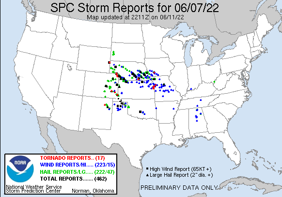
On any storm chase, there is kind of an unspoken goal to see a tornado. However, the vast majority of all chase days do not result in a tornado sighting. Even those who run paid storm chasing tours cannot guarantee a tornado sighting for a weeklong tour. Additionally, resource limitations, which is increasingly the case in the era of $5 gas, can play a factor. Just because a storm is occurring somewhere, at some time, does not necessarily mean a group of chasers has the time and money to get to that storm.

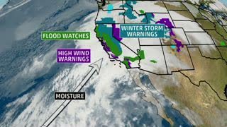
On Tuesday June 7th choices needed to be made regarding where to target and what storms to pursue.

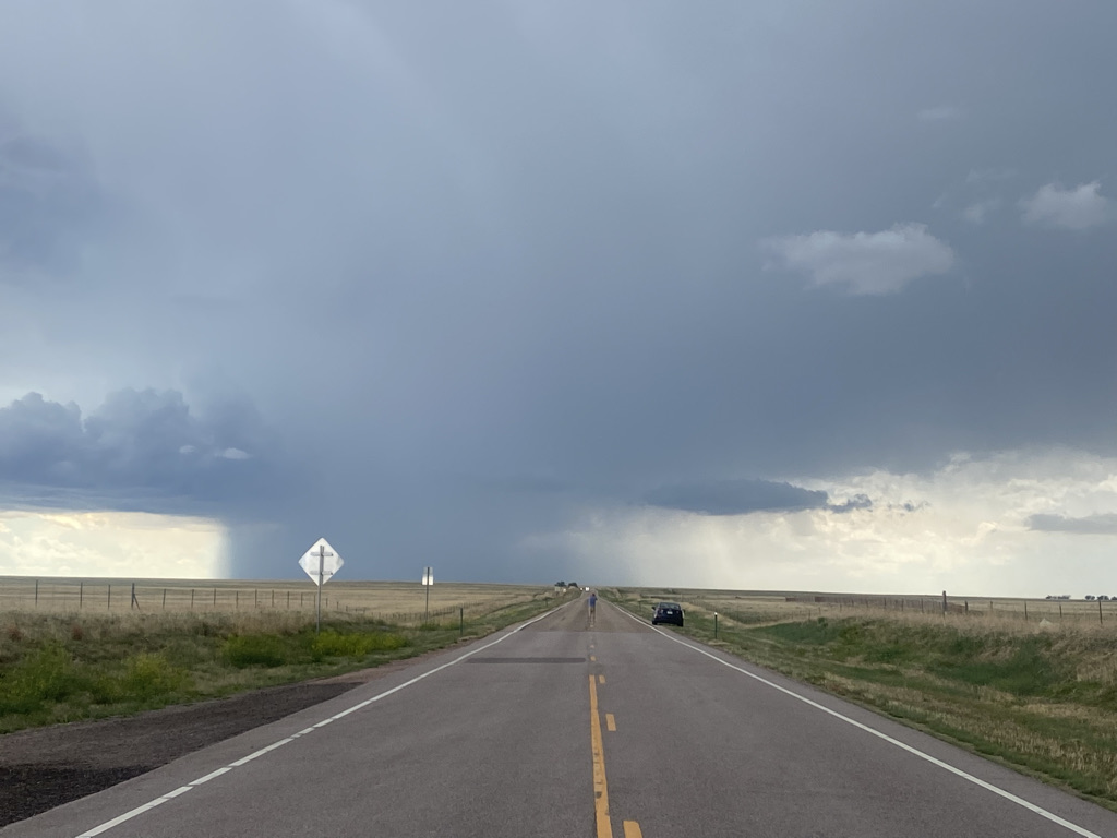
First, a decision had to be made between pursuing faster moving storms across Nebraska and the far northeast corner of Colorado, and slower moving and potentially more discrete (and therefore easier to track and see) storms further south. As is the case with nearly all chase days, other decision points would occur throughout the day. These included what storms to follow, what roads to take, what angle to look at them from and even how long to stand in the middle of an empty highway taking photos.

In a way, storm chasing is all about making decisions. Perhaps the primary education value of storm chase courses is not observing the atmosphere, but in decision making experience.

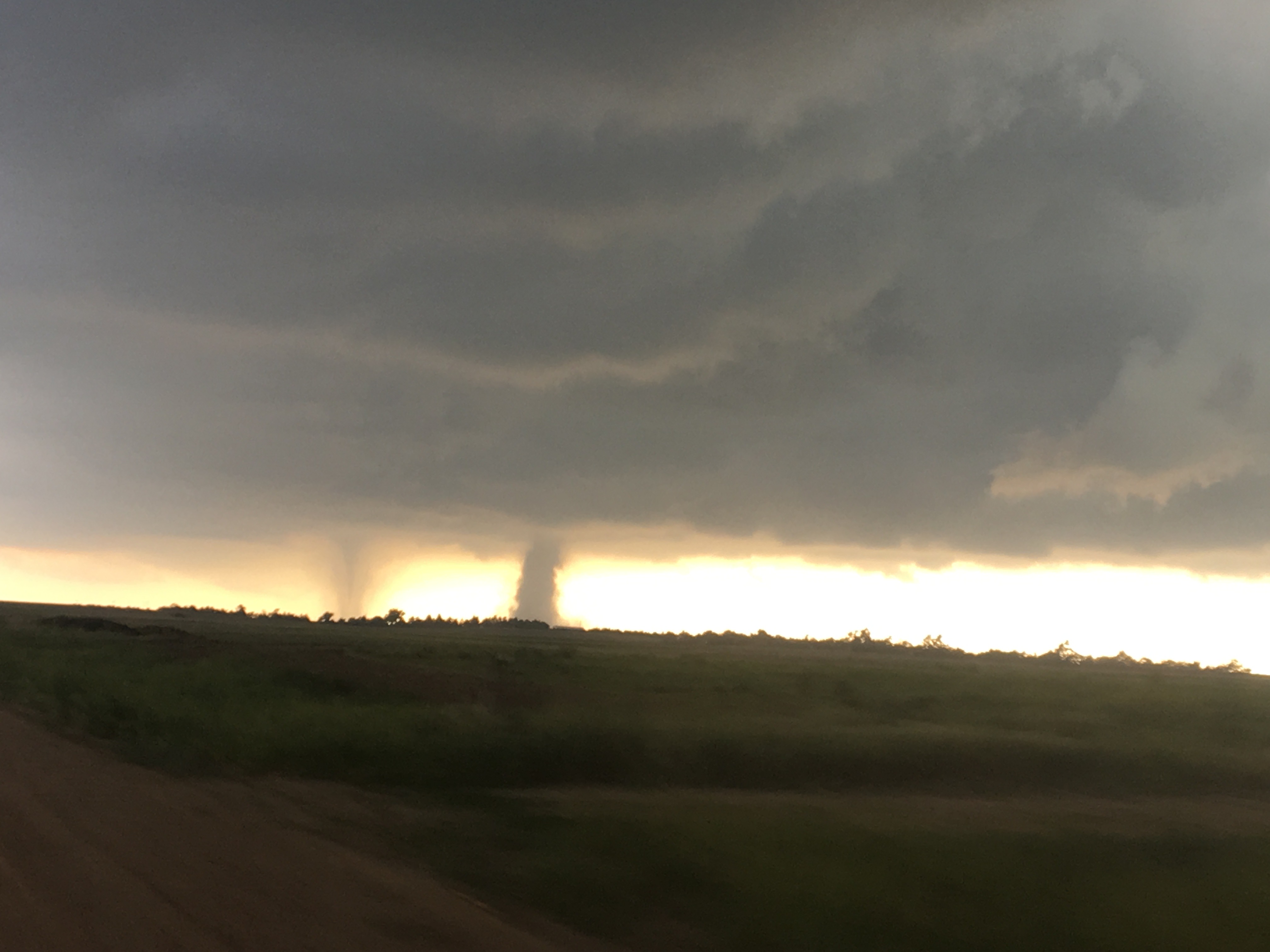
On June 7th, every decision we made was the “right” decision. Or, at least we certainly didn’t make any “wrong” decisions, as has been the case with other chases. We went for the storms further south as there was more moisture there. We followed this one storm that seemed to maintain a steady state for several hours. We saw it from a few different angles.

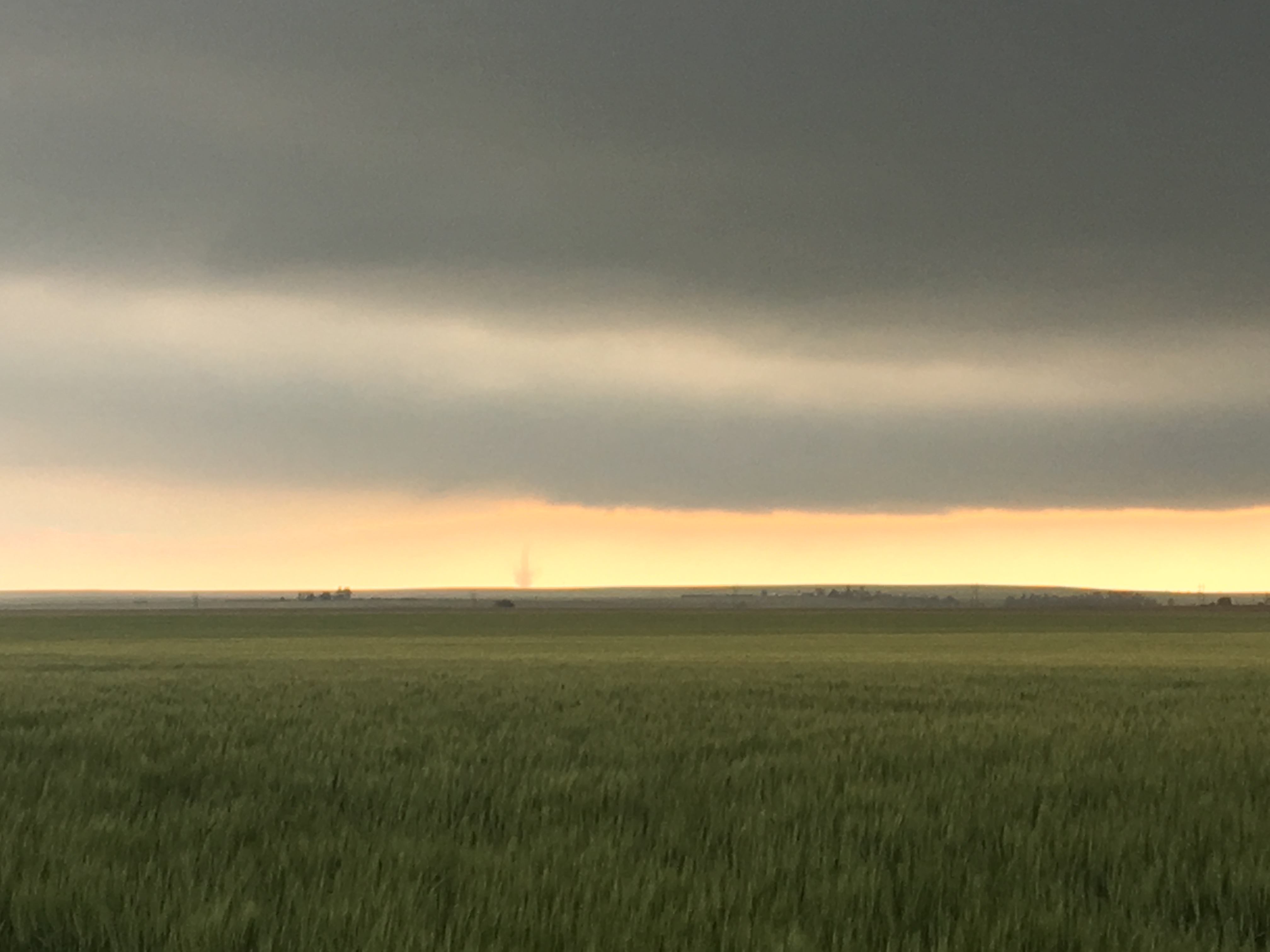
We saw a few dust devils.

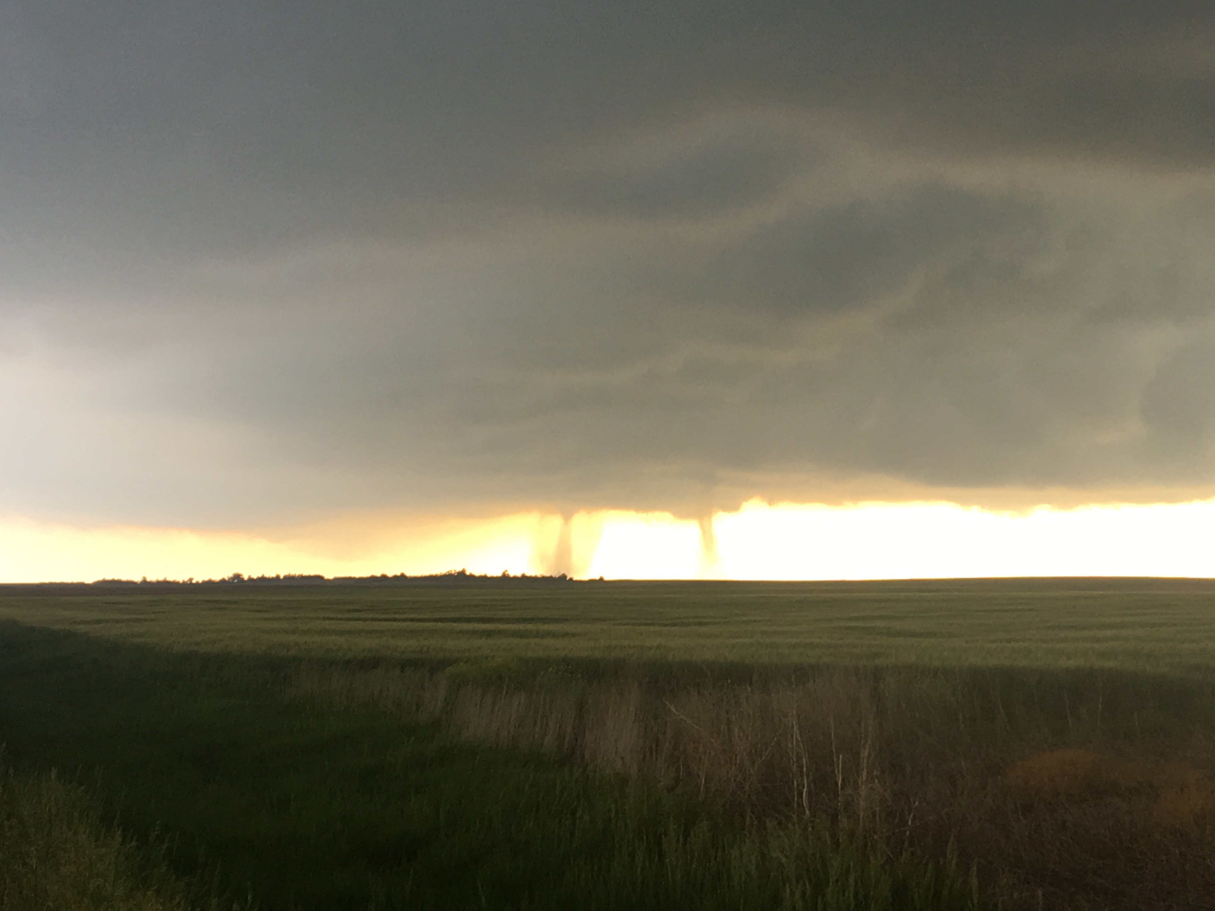
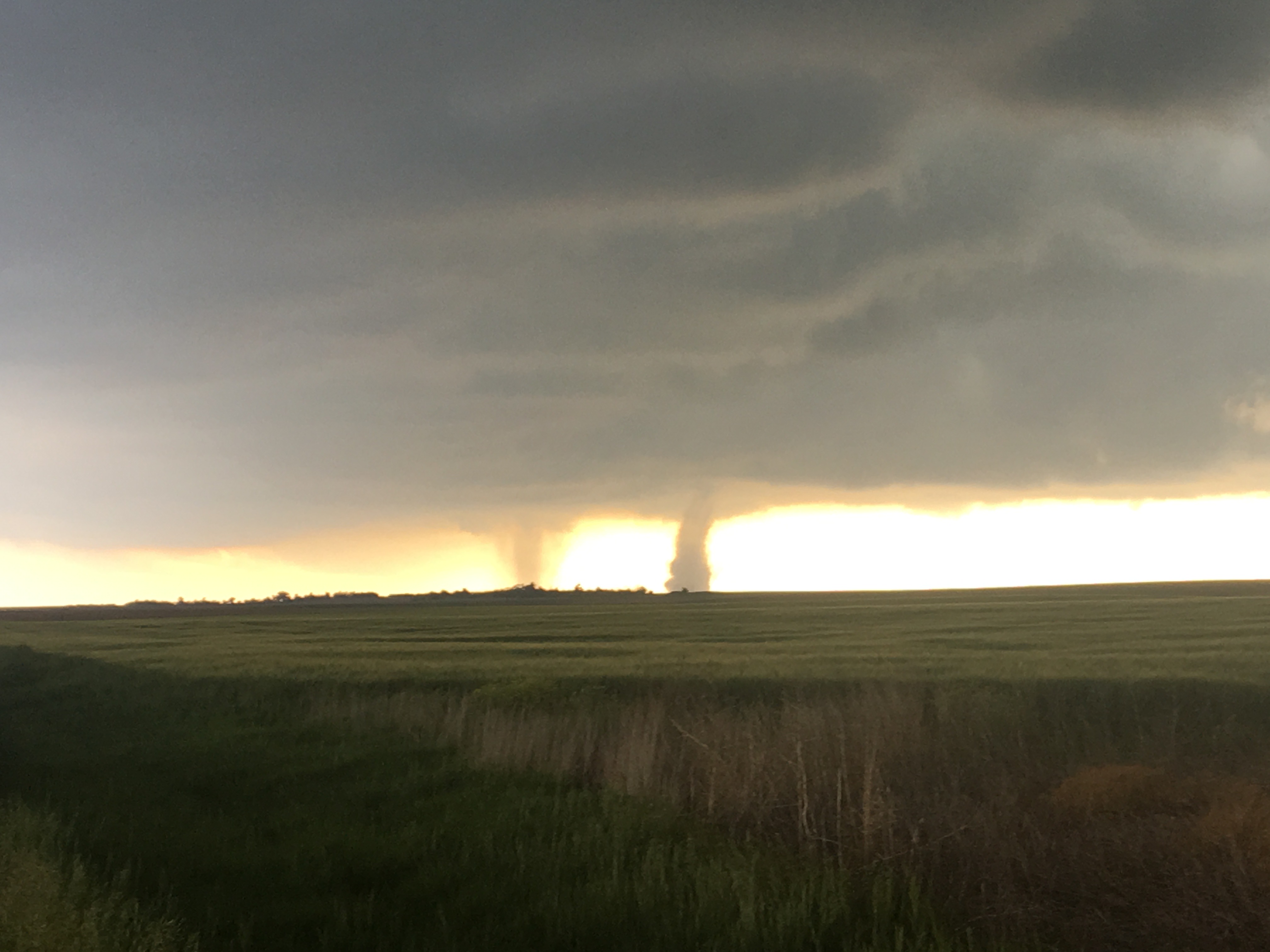
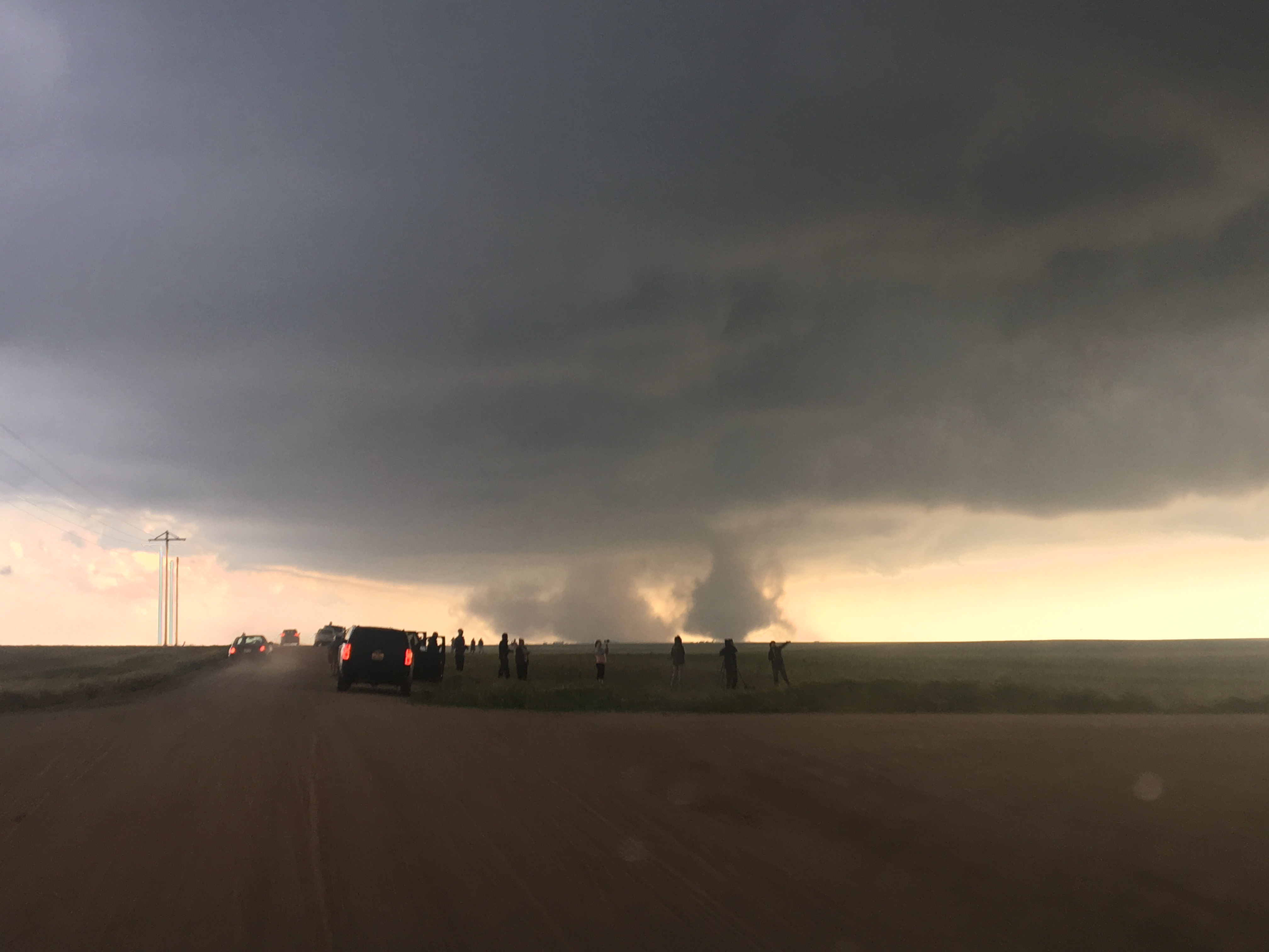
And, on several occasions, the storm looked like it was almost going to produce a tornado.

In fact, it’s still disputed as to whether or not a tornado actually occurred, as tornadoes were reported with this storm.

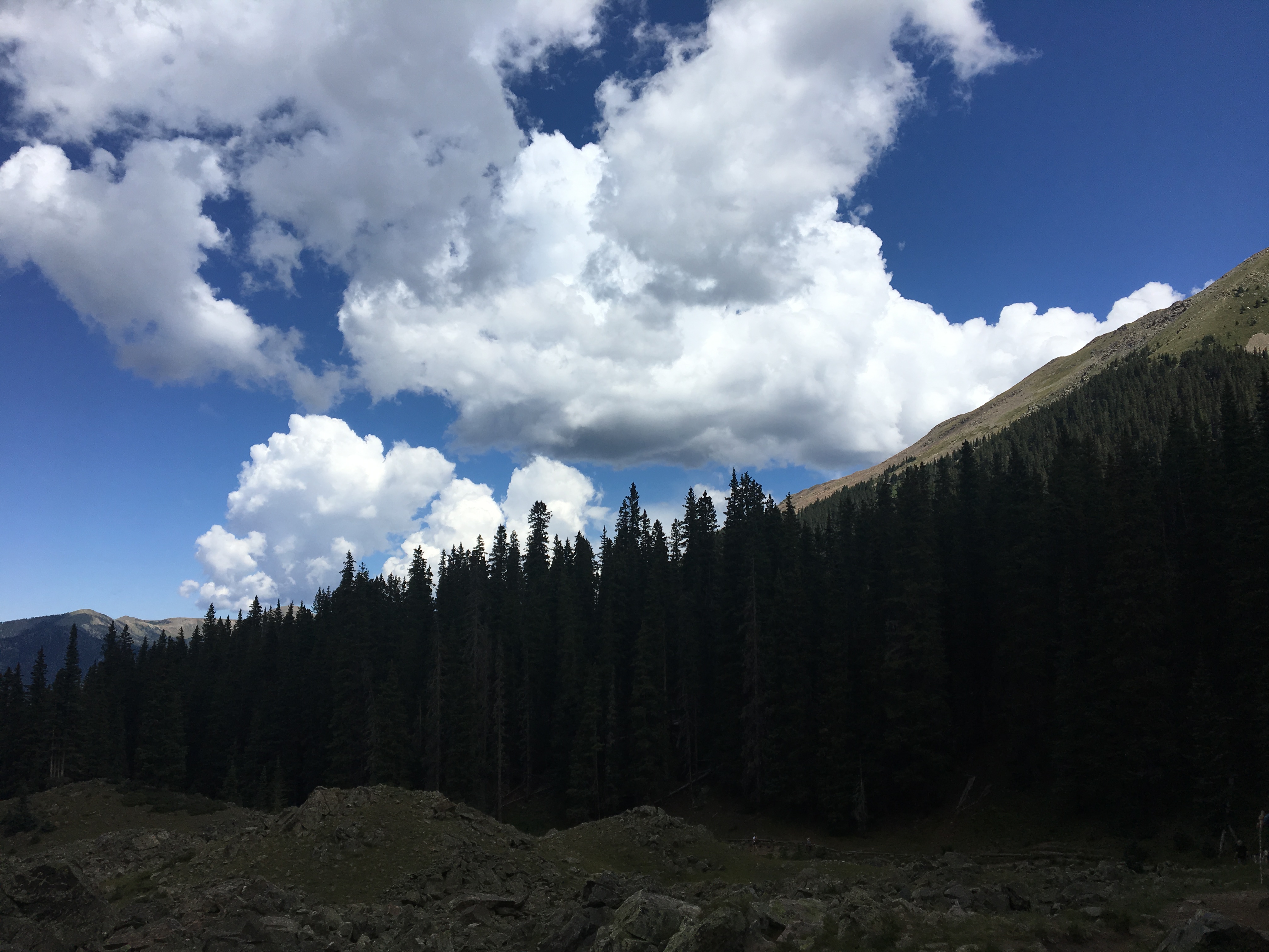
Chasing in this part of the country has its advantages and disadvantages. With wide open spaces and typically drier air, it is possible to see things much further away. However, the road network is quite sparse, and sometimes the only safe option is to view storms from a bit farther away. Therefore, we will never really know if we saw a tornado on June 7th.

Tornadoes are verified by their damage and where we were there was really nothing to damage (perhaps the reason for the sparse road network).

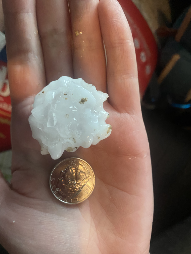
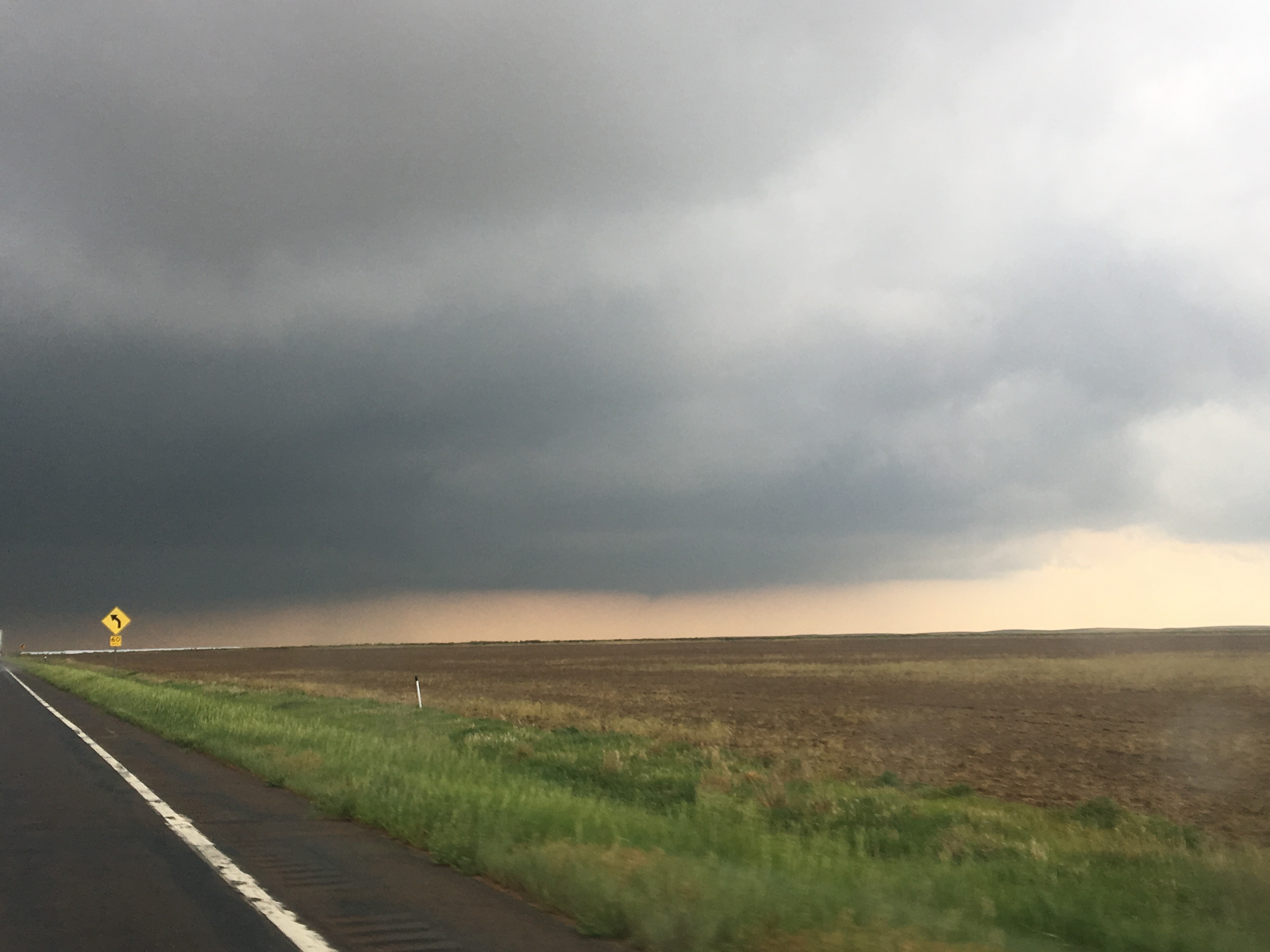
Our chase would end with a close encounter with some pretty large hail.

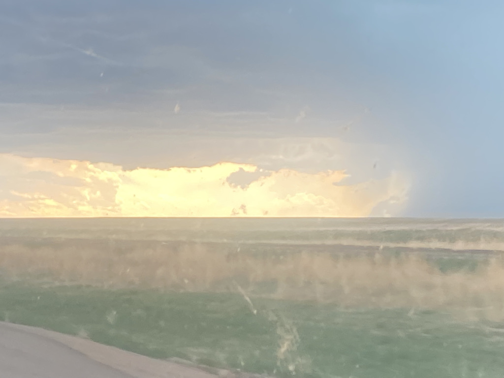
Of all the things I gazed my eyes upon in the sky on June 7th, I was perhaps the most mesmerized by this optical feature that I cannot even classify.

I had never seen anything exactly like this before. It is a combination of colors that can never be replicated, as it is the result of the specific angle at which the sun’s rays hit the atmosphere, water droplets and clouds. It reminds me some form of obscure artwork that one cannot possibly gaze upon without wondering as to the mental state the artist was in at the time of its production. I struggled to look away as the colors slowly morphed.

For some, this day would be characterized as a “success”, given the cool optical features, large hail and dust devils. For others, it is a “failure” as we could not verify a tornado sighting, nor do we feel like we got a really cool tornado photo or video. However, focusing on whether or not we can technically claim we saw a tornado or classifying the endeavor as a “success” or “failure” is not nearly as important as being happy about the process and making the right choices.

Although the most noteworthy events in life are clearly in the category of wild successes or embarrassing failures, most things we attempt in life don’t really fit neatly into one category or the other. There are businesses that make money but lose sight of their original purpose. There are parties that are sort of fun but missing something. There are diet and exercise programs that produce some results but not quite what was initially desired. Some people even reject the paradigm of viewing everything as success or failure, a win or a loss. The key point that this particular storm chase demonstrates is that for all of us to succeed in life, we need to focus more on the actions we take and less on the results. If you go out there, keep taking chances, keep making smart choices and keep learning, the result you are hoping to get will eventually come.

Cycling up Mountains in a Storm

Loveland Pass on Sunday May 23, 2021

Colorado can be a pretty confusing and frustrating place in the Springtime. In most mid-latitude Northern Hemisphere places, Spring is a time of revival. It is the time of year where people who had mostly been indoors and inactive during the winter return to life. Here in Colorado, Springtime is a period of major weather fluctuations. In Denver, March and April are often the snowiest months. It can even snow in May. Sometimes it feels like we go from tracking the weather for snow to 90 degree heat with barely a week or two in-between.

Credit Channel 7 Denver

At higher elevations it snows quite a bit during springtime (Leadville is 10,200 feet (3.1km) above sea level), even as the snow melts into mud on most trails. It is probably the most inactive time of year in the mountains.

Image from Weather Atlas

Springtime in Colorado requires a combination of planning, adjustment and resiliency. The weekend of May 22nd and 23rd would test my resiliency because I kind of dropped the ball on planning.

On Saturday, I climbed Lookout Mountain, a ride in Golden, Colorado that climbs from 5500 feet (1675m) to 7300 feet (2200 m).

The day was somewhat stormy but also quite active. Paragliders took off from Lookout Mountain, flying over the town.

And the road was packed with cyclists. Only about 20 miles (32 km) from Denver, this is a very popular ride!

After noon, with even more paragliders taking off from the mountain, I encountered the storm.

Some cyclists chose to wait out the rain by finding a building to stand next to. I raced back home, into a fairly significant wind down the hill.

The next day, I went up to Loveland Pass to climb another mountain, this one at a much higher elevation. My ride began at the parking lot of Loveland Ski Area, which sits at around 10,600 feet (3230 m). I could already see that the storms had returned.

As is the case with going upwards in elevation, the weather was much colder, probably only around 45°F (7°C) at the start of the ride. From the very beginning, the ride felt like it was taking place in a different season.

Much of the ground was still covered with snow. Unlike on Lookout Mountain, I was the only one on a bicycle on the road up to Loveland Pass that day. The only other people I encountered were backcountry skiing. One joking asked me for a ride to the top of the pass on my handlebars.

Higher up the mountain, I suddenly found myself doing something I typically try to avoid, riding in the snow. It became scary as it was obvious that slippery conditions existed.

Near the top visibility continued to decline.

Finally, just to be true to the cycling community I belong to, I took a photo holding up my bike in front of the sign that indicated I had reached the top of the pass at just shy of 12,000 feet (3650 m).

There I stood, the only cyclist, almost out of place, like I was suddenly in the wrong season. It reminded me of how often we forget that different people in different places are often having quite different experiences. Two months ago, towards the end of March, while most places in North America were seeing people emerge from their winter dormancy and return to life, life in the Central Rockies was slowing down as the ski season was coming to an end. Now, there could not be more contrast all around me.

As the United States has mostly put the COVID-19 pandemic behind us, countries with slower vaccine rollouts are dealing with some pretty bad case numbers associated with newer, more rapidly spreading, variants of the disease. This sits in sharp contrast to last summer, when other more prepared countries had much greater success in containing the virus through behavioral measures than we had. Heck, even the period of time westerners refer to as the “dark ages“, were not a dark time for everybody. The Tang Dynasty was remembered as a golden age for China. It was also a time of great advancement in the Islamic world. Finding myself on my bike in the snow in the second half of May reminded of the benefit of understanding that not everyone and not every place is having the same experience.

Backpacking in the Holy Cross Wilderness: Day 2 The Storm

We woke up to a light rain tapping on the tent. The tiny amount of blue sky present in the morning quickly disappeared. While some days start off rainy only to quickly give way to sunshine, it was obvious this would not be one of those days. It would not be an optimal day for adventure.

Still, we tried to do our previously planned day hike to a couple of other alpine lakes. The rocks and lack of trees in the areas, combined with the cloudy skies, breeze and chilly rain made me think of the Scottish Highlands. I’ve never been there, but have seen photos which always make them appear something like this.I kind of always imagine cloudy weather as well.

The rain started to pick up as fog made previously visible mountains disappear in the background. We retreated to the tent.

As the rain picked up, the cold rain, along with a moderate, started to remind me of how it often felt walking down 5th Avenue (in New York City) during Christmastime. At higher elevations it snowed.

We would spend several hours inside the tent, trying to warm up and dry off. I kind of enjoyed having a chance to relax a bit and read (once I was able to dry off). There is something about having no other options, being stuck, that liberates us from this drive (or expectation) to make the most of every day we have. It feels like a modern day American obsession. I’m not sure if it is our work culture, competitive nature or something completely different that makes it hard for us to just relax. I’m probably even worse than most Americans. Sometimes I wonder what it would be like to waste and entire day, not doing anything interesting or productive, and be okay with it. However, every time I try to do that, I get jittery sometime around 10 A.M.

The sun would eventually come out, sometime around 2:30 P.M.

I showed even more versatility by taking part in an activity I seldom do… fishing.

It even felt warm out for an hour or two.

We brought the fish back to our cooking area (which needs to be away from our campsite because of bears), filleted the fish and cooked our rice … just in time for another storm.

And I mean JUST IN TIME. As soon as everything was cooked, we rapidly and haphazardly put everything away in order to scurry back to the tent with our food to avoid lightning. While the cold wintry rain in the morning was just incredibly uncomfortable, the lightning in the evening was actually potentially dangerous. As summer was coming to an end in the mountains, we experienced nearly all seasons in one day.

It was the most intense thunderstorm I have ever experienced from inside a tent. It was the kind of thunderstorm where the sound of thunder follows the lightning nearly instantaneously making a startlingly loud noise! We could feel the vibration that only comes when the lightning strikes are incredibly close. It even hailed!

2020 is the gift that keeps on giving. It feels like a passive aggressive genie in a bottle, repeatedly giving me what I want but finding the most obnoxious possible way to grant the wish.

Me throughout the 2010s: Our jobs need to be more flexible. The rigid 9-to-5 schedule is outdated.

2020 (Passive Aggressive Genie): I shall create a global pandemic that will force everyone to work remotely out of fear of killing their loved ones with a really intense flu. That will lead to workplace flexibility.

Me in August 2020: There is drought, fires and smoke from California to Colorado. We need rain!

2020 (Passive Aggressive Genie): I’ll make it rain! But, I’ll make it rain on the middle day of your backpacking trip, while you are not in your home or even able to get back to your car. Oh, and I’ll give you both cold wintry rain and scary thunderstorm rain.

Maybe it’s not just me.

Countless people in the 2010s: The rent is too damn high!

2020 (Passive Aggressive Genie): An economic depression, violence and mass exodus from your city will lower your rent. You’re welcome.

Backpacking in the Holy Cross Wilderness: Day 1 Versatility

It started with an amazingly picturesque waterfall, only half an hour into the hike, before even reaching the border of the Wilderness itself.

There is no shortage of amazing natural features along the Missouri Lakes Trail in the Southern Part of the Holy Cross Wilderness about 20 miles South of Vail. In this part of the world it is hard to imagine anything different!

Many of the natural features along the first two miles of the trail were waterfalls!

This otherwise amazing experience along the Missouri Lakes trail was only interrupted by a section of trail that was quite challenging to pass and navigate due to a recent avalanche.

I was told this avalanche happened about a year and a half ago. I had never seen so many trees down in one place and could not help but imagine it being like one of those crazy scary avalanches in those nature videos. I wonder if anyone got trapped, if anyone died. Most people who travel places like this, especially in winter are smart, but there are the occasional stupid ones that end up in the news.

We spent most of the rest of the morning walking by the Missouri Lakes, the feature the trail is named after.

As is typical on the first day of a trip like this, I was trying to clear out my thoughts. Despite my decision to give up news for the month of August, I had some trouble clearing my mind. We can chose not to consciously look at the news, but unless we hide at home alone, there will be things we find out about. I heard about Hurricane Laura’s landfall in Louisiana. I also heard about something that hit closer to home for me, as I spent the first eleven years of my life living on Long Island and regularly going into New York City. Apparently, with the COVID-triggered adaptation of remote work, there is now an ongoing debate about whether New York is “dead” [1] [2].

I was in a place that could not be any more different from New York City.

Yet, my thoughts kept wandering to this debate. I wondered if the reports of people leaving New York City were overblown? Could the city really be facing an imminent decline? If so, will it be like it was in the 1970s? Could it be worse? What would the United States of America even be without places like New York City, where one can be in the middle of everything, the energy, constant movement, and economic activity?

The article claiming New York to be “Dead Forever” made a claim that sounded quite familiar… “This time is different”. I’ve heard this statement many times, in many different forms. Sure, “this time is different” events do happen, but not as often as they are proclaimed. A deep dive into history will actually reveal that in many cases, even ones of major change, a lot of things stay the same. A recent example is Google and Facebook. They changed the world in some ways, but their business model of giving away content for free and marketing to advertisers is not new at all. It started with radio and was the predominant business model of the television era. The main thing they changed was providing a platform for people to produce content for each other rather than paying actors to produce content.

I have a feeling that, although some adjustments will need to be made, there will still be people who crave the energy of living in places like New York.

Going over a mountain pass is quite a different experience than summiting a mountain. Looking ahead at the ridge, it is comforting, especially while carrying a heavy backpack, to know that it is only necessary to reach the “saddle” of this ridge, as opposed to the top of a mountain. There is no chance of a “false summit”. The challenge up ahead looks real, but it is also all laid out in front of us, with no surprises.

The top of the summit would reveal another challenge ahead. The clouds were already gathering.

As we descended the other side of the pass, toward Treasure Vault Lake at about half past noon, it was almost impossible to imagine an afternoon that would not feature rain.

It would take about an hour and a half for us to reach our destination, Blodgett Lake.

Due to a very rocky section of the trail, we had to descend into the valley and climb back to the lake.

For our final ascent to the lake, we went off trail. It’s probably a place few humans venture.

We ended up getting camp set up just in time for the storms to roll in.

The hours of 2:30 to 5:30 P.M. were mostly spent inside the tent, waiting out the storm. It was not ideal, as people often chose activities like this to spend time outdoors. However, we had been outdoors most of the day, and I welcomed the chance to take a nap and do a little bit of reading.

Between the place we set up camp and the lake there was a small lone tree. The image of this tiny tree with mountains and storm clouds in the backdrop made me think of the types of photographs often featured at art galleries, or at trendy cocktail parties.

That lone tree also came to symbolize something else… versatility.

It is common for people to wait for the ideal conditions for their activities. The chilly damp conditions, and promise of more time stuck inside the tent were far from ideal. However, that evening I witnessed a truly stunning natural phenomenon that I had only previously seen in videos. Watching the fog clouds pour over two mountain passes and into the valley below I knew for sure …. It pays to be versatile!

The Highest Point in New Mexico

IMG_8006.JPG

Not too many hikes begin at a ski resort. In fact, many ski resorts have begun to incorporate summer activities; mountain biking, festivals and other attractions. However, that is exactly where the journey to New Mexico’s highest point, Wheeler Peak, begins, at Taos Ski Resort.

IMG_7954.JPG

Wheeler Peak is not nearly as high as Mount Elbert, or many of Colorado’s other high points. It is a strange accident of geography that Colorado is home to 58 peaks that exceed 14,000 feet in elevation (referred to as “14ers”), while the highest point in neighboring New Mexico is only 13,167 ft.

As was the case with many State borers set at the time, a line of latitude (37ºN) was selected to form the border between Colorado and New Mexico. The same line is used for the borders between Arizona and Utah, and Kansas and Oklahoma.

Colorado_14ers_OutsideMag.jpg

All of Colorado’s peaks >14,000 feet in elevation

Yet, all the tallest peaks are contained within Colorado’s borders. Colorado’s Southernmost “14er”, Culbera Peak, is less than 10 miles north of the New Mexico border! Was it sheer luck, or did some sort of force will all the highest peaks be in Colorado?

Despite it not being a “14er”, the hike to the top of Wheeler Peak is actually quite similar. The vertical gain from the trailhead is just shy of 3,000 feet, and the threat of afternoon storms makes it advantageous to start the hike early in the morning.

IMG_7956.JPG

Much of the ascent felt like chasing the sun. We were hiking up the mountain, while the alpenglow would slide further and further down.

It’s a 2.2 mile hike to Williams Lake, the destination for most hiking the first part of this trail.

IMG_7972

This lake was not that crowded at 7:30 in the morning. Later in the day, it would become packed. Also, for those looking to hike to Wheeler Peak, the turn off is before the lake.

The marking for the Wheeler Peak turnoff at 7:30 A.M. and Noon

It is marked by a carving in a wooden stick, which is clearly labelled but easy to miss first thing in the morning.

For those who miss the turnoff, or decide to head to the lake, there is an alternate route. Good luck locating it.

I spent much of the second hour of the hike wondering both where the treeline is, and when I had reached it.

IMG_7986.JPG

The term “tree line” makes it seem like hikers will reach a certain elevation and suddenly leave a dense forest for wide open alpine tundra. However, there are elevations where the trees thin out a bit but do not completely disappear. So, the elevation of the “treeline” is more of a guideline, or an approximation. The Alpine Visitor’s Center at Rocky Mountain National Park indicates that the treeline there is about 11,500 feet in elevation. In Northern New Mexico, that elevation is likely closer to 12,000 feet.

Just above the treeline, we had multiple close encounters with wildlife. First, the marmots chirped at us, as if to say “get off my lawn”.

IMG_7987.JPG

Then, a surprisingly close encounter with bighorn sheep.

IMG_7990IMG_7992

At first I wondered whether these animals were staying away from the busiest trails. However, someone who hikes this trail quite a bit indicated that wildlife encounters this close is actually quite rare on this trail. On any of these trails, encountering wildlife is likely just a matter of luck; whether or not certain creatures happened to be roaming the area at a certain time. After all, last summer I saw mountain goats up close on a very busy “14er” near Denver.

After this, there was a section that is quite challenging. Steep rocky switchbacks quickly ascend the final 1000 feet of elevation gain.

This challenging section ends suddenly with a view over the ridge, overlooking the rugged terrain of the Carson National Forest. The exhaustion that had lead to this point made it even more breathtaking.

IMG_8001.JPG

A quick turn to the right, and the final ascent is made to the highest point in the State of New Mexico.

IMG_8003.JPG

A plaque at the top reveals that the mountain is named after the surveyor who identified this point as the highest in the State.

IMG_8004

I only imagined what it must have been like to be Major George Wheeler, charged with this task, especially at the very beginning. One look around the area, in most directions, revealed dozens of candidates for which peak could indeed be the tallest one in the State. He likely had to scale all of them to determine the true highest point. It reminded me of a situation we all find ourselves in at one point in our lives,. We agree to take on a project or endeavor. Getting started, me suddenly come to the realization that it is going to be significantly more work than anticipated.

IMG_8006

Having many other peaks in the area that are nearly as tall gives it a pretty unique feel at the top. The plethora of similar peaks may have also contributed to the pleasant conditions at the top. There was surprisingly little wind at the top of Wheeler Peak that day (August 31, 2019).

IMG_8010

The descent is also an interesting experience. Some of the steepest parts of the trail can be downright scary, and just as challenging as it was on the way up. It is also interesting to encounter the people that are still trying to reach the peak.

This aspect of the hike is a strange and somewhat depressing transition. At the start of the descent, still only a couple of hundred feet from the summit, it feels great to give hikers, often exhausted, encouragement and reassurance that they are “almost there”. Continuing downward, this transitions to having “a little bit to go”, to either no comment or vague encouragement.

If there is a depressing time of day on an amazing hike like this, it is 11:15 A.M. This is the time of when I start to realize that those that those still trying to get to the summit are probably not going to make it.

There is a safety concern behind this. Lightning is quite dangerous, even more so above treeline. Lightning is always looking for the fastest path to the ground. Regardless of where you are, if you’re outside, there is always a chance this can be you! Above treeline, without tall trees to theoretically provide that path, hikers are even more likely to be struck.

Surely enough, at 11:45, I heard thunder, and saw the convective clouds starting to build.

IMG_8019.JPG

I just hope that everyone in danger got off the mountain and stayed safe! While policies, attitudes and even the height of the peaks may be different on either side of the 37th parallel, some things are the same. This includes how mountainous topography creates thunderstorms, how lightning behaves and how our bodies react to being struck. Danger aside, it is refreshing to know that regardless of boundaries created by humankind, there are things we can always count on being true.


Park City During Peak Ski Season

IMG_5753.jpg

North America has its fair share of iconic ski towns; places frequented by winter sport enthusiasts, particularly skiers and snowboarders at this time of year. On one level, the experience in most of these towns is quite similar. There are the hotels and condos, restaurants, sporting goods, all those T-shirt shops, and some form of nightlife to cater to the many young and active people that visit every year.

However, there are some major differences between these towns and the resorts around them that create different experiences. The town of Park City is perhaps most similar to Breckenridge, in that it is a town that was settled in the middle of the 19th Century as a mining town.

IMG_5794.jpg

This contrasts with towns like Vail, which were built up around the ski resort after it opened. Also, as is the case with places like Crested Butte and Whistler, the manner in which the town is laid out, the cultural vibes, and of course the resorts themselves make each place a unique experience.

IMG_5775.jpg

Visiting Park City February 9-13, skiing the 10th-12th, produced what is perhaps the most typical Park City ski vacation experience, as it is right in the peak of the ski season, but not a holiday or a special event.

This time period also produced a good variety of weather and snow conditions, with a snowstorm rolling in Sunday afternoon, but Monday and Tuesday’s weather being clear.

After this experience, I have concluded that the Park City experience is unique for the following five major reasons.

1. Accessibility

ParkCity_SLC

For people traveling from other parts of the country, this is a major draw. The drive from Salt Lake City International Airport to Park City can typically be done in well under an hour. Getting to most other resorts in North America requires either a longer drive or flying into a smaller airport.

2. Utah Culture

IMG_5714.jpg

Saturday evening, my first night in town, I walked into Wasatch BrewPub, which is at the south (and high) end of Main Street. Arriving at a brewpub at 9:30 on a Saturday night is something that feels quite normal to me. Yet, upon arrival, I was informed that last call is in a half an hour.

All the tap beers on the menu were listed at 4.0% alcohol by volume, also reflecting Utah’s culture of caution when it comes to consuming alcohol. There are, however, ways around this.

IMG_5723

3. The Resorts

Several years back, Park City and the Canyons combined to form a mega-resort.

IMG_5726.jpg

Like Whistler-Blackcomb, the formerly separate resorts are connected by a gondola.

IMG_5787.jpg

Both sides of the mountain have some epic skiing, including aspen glades.

Skiing through the aspen trees is somewhat of a unique experience, as, due to climate and elevation, not all resorts have areas like this.

The Park City side of the mountain probably has the best bowl skiing.

IMG_5791

Skiing areas like this after a fresh snow is a unique, however exhausting, experience.

Deer Valley Resort, just a couple of miles outside of town, is the site of many events at the 2002 Winter Olympics.

IMG_5764.jpg

It’s the kind of place where skiers can pretty much do it all, from skiing really fast on a groomed trail.

IMG_5754.jpg

To going deep into the woods and encountering random cabins.

IMG_5757.jpg

One thing I love about the resorts in Utah is that some of their trails have a double blue, or advanced intermediate rating. In my opinion, the variety of types of trails at many ski resorts in Western North America warrants some being given a rating between blue (intermediate) and black (expert).

IMG_5756.jpg

There are, however, some potential annoyances for some visitors. Like many ski areas around the world, Park City has gotten into the cross-hairs of the arms race between competing multi-resort ski passes. Park City resort (which includes the Canyons) is on the Epic Pass, while Deer Valley is on the IKON Pass. Visitors who want to ski both resorts cannot do so on one pass, they must either purchase a one day pass at one of the resorts (as I did), or have both passes (I did meet someone on a ski lift ride that did purchase both the Epic and IKON passes).

Also, Deer Valley is one of only three resorts in the country that does not allow snowboarders.

4. Snow Conditions

IMG_5734.jpg

Different parts of the country have different snow conditions. Resorts closer to the East or West coast tend to have wetter snow than those in places like Colorado. Utah’s snow this February was kind of a mix between the two, as much of the snow in the area had come from the same series of storm systems that dumped heavy snow in California.

AtmosphericRiver2019

These storms have tapped into tons of moisture from the Pacific Ocean, bringing snow to Utah that has some resemblance to the snow at resorts closer to the West Coast.

5. Parking

IMG_5710.jpg

Aside from the strange way things close earlier than expected, I love Park City’s Main Street. The lights hung across the street and not so gentle slope from one end of the street to the other produce an evening atmosphere that just feels positive and festive. However I have never seen a street with so little available parking also have so little through traffic. It felt strange to look for parking for so long but also be able to stand in the middle of the road so frequently! Luckily, Summit County Utah has free busses visitors can take all over the areas, most of them going to Park City’s Main Street.

Memorial Day Tornados in Eastern Colorado

IMG_3528

2018 has not been an active year for tornados. With May, the most active month for tornados nearly complete, only 416 tornados have been reported.

Tornados_2018vsClimo

This is, by any scientific measure, over 35% lower than the long-term average, and according to the Storm Prediction Center, in the bottom quartile for tornado activity.

This Memorial Day storm chase almost came as a surprise. First of all, I typically travel Memorial Day Weekend, as does a lot of people. Also, with the season being as inactive as it has been, there had been plenty of days throughout May where forecast models looked promising for a good storm chase several days to a week ahead of time, only for the atmospheric setup to never materalize.

While some aspects of weather forecasting have become quite accurate, forecasting weather beyond a few days, and forecasting weather phenomenon on a small spatial scale remains a challenge. Thus, those that long to see what is perhaps nature’s most violent storm, tornados, can do one of two things. They can set aside a period of time, typically sometime either in May or early June to go out and look for storms.

IMG_3542.jpg

Several companies offer this service, a set 7 to 10 day chase in vans like these ones. However, even in May, there is no guarantee that any kind of active thunderstorms will be happening, let alone tornados. Those that have ever chased in this manner end up becoming familiar with all sorts of oddball attractions in the Great Plains!

20130921-094233.jpg

There are also those that keep an eye on weather outlooks, deciding to go when the setup looks good. This requires some often last minute decision making, and sometimes chaining plans. This is what I did on Memorial Day. A day that started out slowly, with brunch in Cherry Creek, quickly transitioned to traveling due east out of Denver, straight into the storm.

IMG_3485.jpg

Still, even if this tactic guarantees that there will be activity, it does not guarantee that there will be tornadoes. There is still some element of luck to it.

IMG_3486.jpg

Near the tiny town of Cope, Colorado, the sky had an interesting orange hue to it with what appeared to be a funnel cloud. This can actually happen quite frequently without an actual tornado being spotted.

At that point in time, around 4:30 P.M., we made two decisions that would put us in the right position to view the tornados. First, we decided to get to the East side of the storms before they became big. Second, we decided, due to Eastern Colorado’s sometimes limited road network, to actually use dirt roads, something that can, at times, be dangerous in the case of a flood.

IMG_3490.jpg

The first tornado, Southwest of Cope, we saw kind of in the distance.

IMG_3496.jpg

We traveled south, along a dirt road, to get a closer view of it, however, we eventually saw it dissipate.

IMG_3498.jpg

Still, the entire time, cloud formations indicated a strong low-level rotation, conditions necessary for tornado development. There was even a “landspout” and several dust devils between the storms.

IMG_3505.jpg

Before long, two new tornados were spinning up, just a bit to the South and East of where we had seen the first one.

IMG_3511.jpg

The strange thing about these storms was that they were first visible on the ground, with clouds of debris extending outward from both emerging funnels.

IMG_3515.jpg

Watching them develop proved quite remarkable. First the funnels showed, then we actually got to see the darker clouds of debris around the funnel fill in from the ground up, forming two side-by-side fully mature tornados.

IMG_3520.jpg

The funnels were on the ground for about half an hour.

They gradually evolved, taking on different forms, giving way to yet another tornado, a bit further South and East, near a tiny town called Vona, CO.

IMG_3539.jpg

As a person with many interests, I only end up storm chasing several days per year. In the past several years, this was by far the most successful chase day. Even for the most knowledgable chasers, just seeing a tornado constitutes a successful day. Seeing four of them, as well as being able to watch tornados form is nothing short of amazing!

I am also always glad to see when tornados are not actually impacting people where they live. One thing I notice is that storm chasing continues to become more and more popular with time.

IMG_3533.jpg

There were several instances where we encountered large groups of people, just like this one, looking at and taking pictures of tornadoes. This is all good, but I do concern myself with how the people who live in these areas perceive this activity. We storm chasers should never be delighting in the destruction of anyone’s home or town, and I am concerned that the perception as such could lead to some resentment among the people who live in tornado prone areas, particularly the Great Plains, which far Eastern Colorado is part of.

IMG_3547.jpg

Not only was it one of the most successful chases of my life, but it also was quite possibly the most efficient chase I have ever been a part of. It started after what turned out to be a 90 minute brunch, and that evening I was back in Denver seeing a concert at Red Rocks Amphitheater.

The perfect storm chase, like the perfect setup when it comes to things like jobs, relationships, communities and homes, results from the intersection of good decisions and good luck. The former can be controlled. The later cannot. Just as I have been on many other storm chases where my group made all the right decisions but still did not see any tornados, the same can happen in all of our pursuits. All we can do is continue to go out there, make the right decisions, execute properly, knowing that the luck will eventually materialize even if it takes several more tries.


Backpacking in the Weminuche Wilderness: Day 2

IMG_7153

Before moving to Colorado, I experienced seasons in a completely different way.  While there would be some anomalies, for the most part, winter was winter and summer was summer.  Snow was something I experienced starting in November, through the winter, probably one last time in early April, and then not again for 6-9 months.  Likewise, heat would be primarily confined to the summer months.  In other words, I experienced being cold and being warm in two separate parts of the year.  The experience would generally only mix during the in between seasons; mid-spring and mid-fall.

In Colorado it’s all different.  In Denver I’ve seen temperatures reach the lower 70s (23 C) in the middle of February.  At higher elevations snow can fall nearly year round, and there are places where snowpack persists well into the summer.

IMG_7154.jpg

Saturday morning, the start of my second day in the Weminuche Wilderness, was a cold one.  The chill had awoken me at 3:00 in the morning, when I reached for my warm hat and for the zipper to zip my sleeping bag all the way shut.  At roughly 6:30 I woke up for good, and crawled out of the tent to find ice on the fly!  Frost was found on many of the items we left outside, including this bear cannister.

It warmed up fairly quickly at the campsite making me wonder why I did not simply stay inside the tent for another hour.  All the weather forecasts we had looked at prior to this backpacking trip had indicated that a wet period was coming to a slow end, and that each day would get progressively drier (lower probability of rain).  Yet, in the morning I saw something that would indicate differently; alto-cumulus clouds.  These are puffy clouds with a base somewhat higher up in the sky than the clouds we typically see.  On some storm chases, the presence of alto-cumulus clouds indicated the presence of moisture at higher levels of the atmosphere.  This was seen as a good sign on a storm chase, but, on a backpacking trip, is a bad sign.

The first few miles of the day took us by a lake we are glad we did not chose to camp at the prior evening, and then back into the woods, where once again the trail was muddy kind of on-and-off.

Headed farther up in elevation, towards the summit of the day, we approached the tree line, encountering several waterfalls.  This one, by far, was the most pictureqsue.

IMG_7175.jpg

I did not even know the name of any of these waterfalls.  In fact, I did not even verify that they even have a name.  It didn’t even seem important at the time.  We just liked what we saw.  At that time, most of the conversation within our group revolved around whether we would see marmots in the nearby rocks, and speculation as to what elevation the tree line was at at this latitude.

We followed the Rincon La Vaca (Cow Canyon) trail, which is also considered a section of the Continental Divide Scenic trail, above the tree line, and approached a rock formation we had been looking at since early the prior afternoon, “The Window”.

IMG_7183

This is where we decided to stop for lunch, at a lake where we could safely refill our water bottles.

IMG_7188

It was noon when we finished eating lunch and, four of us (out of a group of six) decided, despite the potentially ominous weather, to make a side excursion.  We dropped our packs and hiked the 500-ish feet (and half a mile) up to “The Window”

We got back to the lake, where our backpacks were, around 1:00.  As soon as we prepared to move, and catch up with the rest of the group, it started to rain.  A few minutes later, ice pellets began to fall from the sky.

IMG_7200

We briefly took shelter from the inclement weather, but eventually soldiered on through the not quite rain not quite ice, which would eventually change over to snow!

IMG_7203.jpg

I experienced a lot of this living in Chicago.  I called it “precipitation jambalaya”.  But, I never thought I would hike through it, and, well, am used to experiencing this in December, not late August!  Once again, that thing about the seasons!

IMG_7205

The precipitation stopped right before we turned off the Continental Divide/ Rincon la Vaca trail, and started looking for the trail we would take back towards the reservoir, the East Ute Creek Trail.

IMG_7207

The scene looked familiar.  The shape of the Ute Creek Valley where we were headed, with an open meadow surrounded by mostly dead forests on either side looked quite similar to the Weminuche Creek Valley we had hiked through the prior day.  The trail, though, was hard to find.

For the first mile we kept losing the trail, or we just saw it show up only as a barely visible line in the grass.  We actually speculated as to whether or not this trail was so infrequently used and/or maintained that mother nature was basically starting to take it back!

IMG_7213IMG_7214

We hiked until roughly 5:00 P.M., and by the time the day was over we hike a total of 10.2 miles (11.2 for those of us that took the side excursion to “the window”).  The last hour featured two crazy river crossings where we actually removed our socks and shoes.

We found a campground near a small lake called Black Lake, where, once again, the weather took a turn for the worse.

IMG_2867.JPG

The rain started shortly after 6 P.M., and did not let up until after sundown.  I rushed back into my tent!  With all of the experiences of the day, the mixed precipitation at over 12,000 feet elevation, wading through water, and now, once again, more icy rain, I was cold!  I was way colder than I wanted to be, and way colder than I ever imagined being in the month of August.  For the first 20-30 minutes, I had to lie sitting still inside my sleeping bag, otherwise I would start to shiver.

All I could think of were things that were HOT and DRY.  I wasn’t even thinking of warm, pleasant experiences, like drinking rum on a beach in Puerto Rico at sunset.  I was thinking about things that would immediately heat me up and dry me off; sheets that were pulled directly out of the drier, a sauna, Death Valley!

IMG_7237

With the hard hiking parts over with, I had originally hoped to have kind of a party with the group on Saturday night.  We had even brought flasks, filled with whiskey for such an occasion.  But, the weather changed my plans, as the rain continued and I continued to periodically hear thunder through the 7:00 and 8:00 hours.

I also did something I never do on group trips; read.  I joke I often bring a magazine or even a book, places, but never touch it.  This time I actually read.  It was the July edition of Adventure Cyclist.  Fitting for the mood, thinking about warm places while trying to stay warm, I read full stories about cycling journeys through Morocco and Hawaii, both warm places!

I guess regardless of whether you are in an urban setting or in the wilderness, life has a way of changing plans.  In the city, it is some merger, or a random change in commodities prices.  In nature, it is the weather.  But, when it comes to rain, and anytime rain changes my plans, I always do my best not to complain.  Even while I was bummed that I was not partying with my friends and hating how cold I was in my tent, I was mindful to remember that rain is necessary for the food we eat, the water we drink, as well as everything that made this trip possible in the first place.  I do not want to be one of those people that fails to realize this, and cannot put up with a little bit of rain.


A Stormy January Weekend in the Mountains

2015 is already off to an adventurous start for me.  This past weekend, the first weekend of the new year, I had the opportunity to accompany some friends on a trip to their cabin in Alma, Colorado.  Alma is the highest incorporated municipality in the United States (with permanent residents).  It is about 15 miles South of Breckenridge Ski Resort along state highway 9.  However, between Alma and Breckenridge lies a mountain pass, called Hoosier Pass, as well as the Continental Divide.

Still, visiting Breckenridge ski resort is significantly easier staying at a place like this than it is driving up there from Denver in the morning.  Not only is the distance much shorter, but there is no need to plan around the traffic patterns along I-70.  On a typical weekend day in Colorado, skiers traveling along I-70 from Denver to the area ski resorts must leave by around 6:00 A.M. to avoid significant delays.  The trek from Alma up to Breckenridge is typically only delayed by weather, and even if delayed will take significantly less time.

IMG_2997 IMG_2998

Unfortunately, this past weekend turned out to be one of those weekends.  Waking up Saturday morning (after driving up from Denver Friday evening), I was amazed by the views from the cabin!  The cabin, which is located in town, and walking distance from the town’s main street, sat on the side of a hill, with forests around it in every direction.  However, I was also startled to see some low clouds appearing to our North, the very direction we needed to travel to get to Breckenridge.

The ski day was kind of a mixed bag.  With a significant amount of recent snowfall, the snow was in really good shape- neither icy nor “skied off”.  However, as the day progressed, the snow began to pick up, and so did the wind.  With temperatures in the mid to upper teens most of the day, and winds picking up to about 15 mph, the wind chills were commonly near 0!  This, along with the sensation of snow hitting me in the face at high speeds (especially on faster trails going 50 mph), made the conditions less than ideal.  In the end, we decided to do slower runs in the trees, and still ended up with a really good day of skiing.

This weekend’s weather caught us by surprise– partially.  I know it is quite dangerous to be in the mountains when a major storm hits.  And, when a major storm is on it’s way, I tend to stay home.  However, this weekend’s storm was quite minor by Colorado standards.  48 hour snowfall totals across most of the region were only a couple of inches, not enough to make me reconsider any plans.  However, an area of heavier snow happened to occur right over Breckenridge.  The map below indicates snowfall totals this weekend.  The one little “bullzeye” of snowfall exceeding 6″ is located right over Breckenridge!  So, we were impacted by the most significant part of fairly minor storm system.

CO_Precip_2015_1_03_04

This made for a treacherous drive back over Hoosier Pass at the end of the day.  However, when we got back to Alma, it was not snowing at all.  In fact, the vehicle left at the cabin did not have any snow on it, and we did not have to shovel snow in front of the cabin.

In many parts of the country, seeing such drastic differences in weather conditions over the stretch of only 15 miles is quite a strange occurrence.  However, up here in the mountains, it is actually quite normal due to the impact the topography has on storms coming through.  Alma is considered part of South Park, a flat region of Central Colorado with elevations near 10,000 ft.  Due to it being surrounded by mountains in all directions, this region is significantly drier than other parts of the state.  The town of Breckenridge, at 9600 ft. in elevation, is actually more than twice as likely to receive significant precipitation in the winter than the South Park area, and receives more precipitation all year round.

co_precip_Breck_Alma

When selecting a home, whether it be a permanent residence, or a second home (vacation home), there are many factors to consider, one of which is location.  This weekend, with it’s kind of moderate snow event, provided a good showcase of both the advantages and disadvantages of choosing a place like Alma to have a cabin.

The major advantage seems to be how much you get for your money.  This place we stayed at is quite nice.

IMG_3006 IMG_3001 IMG_3002

It has three levels, each with it’s own sizable bedroom.  Each one has a different theme appropriate for the mountains.  The middle floor has a large kitchen, dining, and entertaining area.  And, perhaps one of the best features is the water heaters, which provide so much hot water that one can take a lengthy hot shower after a long day in the snow without having to worry about running out of hot water.  Overall, it is way more luxurious than any place I had stayed at closer to the ski resort.  I can imagine a place like this closer to one of the major ski resort being significantly more expensive.

However, the drive over Hoosier Pass in the snow was a clear demonstration of the downside of choosing a location like this.  Those with second homes in town would not have to travel too far to get to the resort, and not have to deal with icy roads and dangerous conditions.

IMG_3009

In addition, from this location it is also significantly less convenient to reach some of the other major ski resorts in the area, particularly Vail, Beaver Creek, and Copper Mountain.

Of course, the entire construct of this tradeoff implies a passion for skiing, because it is this passion for skiing that largely forces the pricing of these second homes in Central Colorado.  For those who prefer other activities, Alma, and the rest of South Park is quite an attractive location.

In the summertime, it is quite easy to reach tons of great hiking trails, including about a dozen “14ers” (peaks of 14,000 feet or higher).  And, a straight shot down an easy to travel highway is Buena Vista, the site of the most popular whitewater rafting river (the Arkansas River) in the country.  Finally, for those who just like solitude, the town’s population is only 270.

Due to the uncomfortable conditions, we decided not to ski again on Sunday.  Rather, we slept late, and made a leisurely journey back to Denver avoiding any traffic delays that could have built in the afternoon.  It was the prudent choice, even if we theoretically could have pushed ourselves a bit more.  Part of life in the mountains is having to accept some last minute changes in plans based on highly variable weather conditions.  So, in a way, changing up the plan for Sunday was part of an authentic mountain experience.