Category Archives: geography

Backpacking in the Weminuche Wilderness: Day 3

IMG_7252

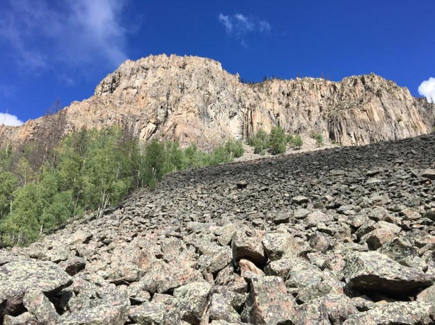
The Weminuche Wildreness appeared to be particularly devastated by the recent Mountain Pine Beetle epidemic.  While a portion of the second day was spent above the tree line and in storms for much of the journey, we wound our way in and out of the forest, alternating between hiking through the forest itself, and hiking across an open meadow where we could gaze upon the forest to both our left and our right.

IMG_7229

Throughout the State of Colorado, and throughout the West, I observe areas where the Pine Beetles have decimated the forest, changing the ecosystem forever.  Nowhere, though, have I seen a higher concentration of dead trees.  I would estimate that, over the course of the trip, some 70-75% of all the pine trees I saw, were, in fact, dead.

IMG_7228

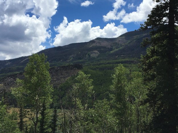
But I did notice some signs of life, particularly at the campground Sunday (Day 3) morning.  Tucked away amongst the densely pack forests of decimated trees, little signs of life seemed to appear.  It reminded me of many American cities, circa 1982, decay being the overarching theme but, signs of life and pockets of hope beginning to appear here and there for those willing to observe.  Maybe indeed, the worst has now passed for this particular forest.  As was the case for many of our cities, it is possible that in a decade or so, we will revisit areas like this, and see once again a thriving forest, albeit, as was the case with our cities, with a different character?

IMG_7246.jpg

As is typically the case on a three day excursion like this one, the last day was primarily a descent.  As we descended, we quickly reached elevations where Aspens, rather than Pine trees made up a significant proportion of the forest.

IMG_7267IMG_7268

Maybe it is different at this latitude, farther South than the Denver area, where I live and spend most of my time.  But, it feels as if in this wilderness, Aspen trees are able to grow at some pretty high elevations.

IMG_7302

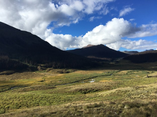
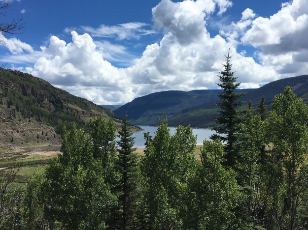
We figured out the tree line here to be somewhere close to 12,000 feet in elevation.  When looking upon sections of forest from afar like this, it is easy to picture some of these Aspen trees living at elevations close to 11,00 feet.  Over the course of my four years in the Denver area, I had grown accustomed to them disappearing between 9,000 and 10,000 feet.

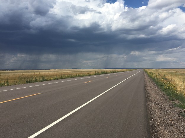
Sunday’s hike was a 7.3 mile trek along the Ute Creek trail (the East Ute Creek trail we had followed the previous day merged with the main Ute Creek trail).  The trail alternated a bit, climbing up and out of the valley formed by the creek for some sections, and descending back toward the creek for others.  Due to the previous night’s onslaught of rain, which likely impacted the entire valley, the trails on this, the final day, were at times even muddier than the were the prior two days.  At the end of three days, our total distance came out around 25 miles.  I speculated as to whether the extra distance we traveled stepping around puddles, and veering left and right to avoid some of the muddiest sections of trail, over the course of three days made this a mile or so longer than it would have been had the trails been completely dry.

IMG_7287

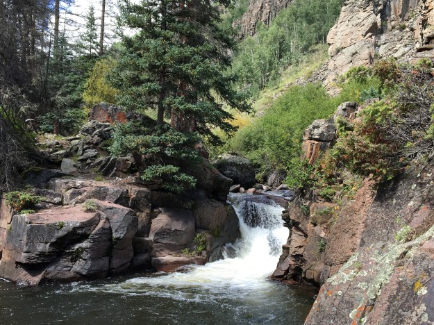
I personally added some distance on top of that.  I love side excursions, whether hiking/backpacking, cycling, or on a road trip.  And, in addition to the side excursion to the feature known as “the window” the previous day, I took one completely on my own the final day.  Roughly halfway through the hike, I saw a place where I could cut down to the creek, and see a mini-waterfall.

IMG_7291

The final part of the day consisted of a small climb out of the Ute Creek valley, followed by a descent back towards the Rio Grande Reserviour.

IMG_7299

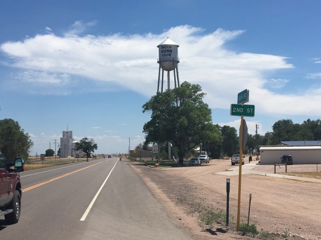
It is inevitable that, on the last day of any trip, we all begin to ponder our return home, and a return to our “normal lives”, whatever they may be.  This return, though, is somewhat unique, as a trip into the woods is not just a journey away from our jobs, or certain responsibilities, it feels more like a complete separation from the modern world, or as some people refer to it, the “real world”.  All of us were separated, not just from work, but from TV, from the news, from Twitter, and even the manner in which society is structured in the 21st Century.

Since my return to Denver was a return to, after being completely separated from, the “real world”, I started to contemplate the “real world” as one big entity, which, even for a big-picture abstract curious minded thinker like me, turned out to be strange.  I feel like we often compartmentalize the “real world” into buckets; the working world, the relationship world, the school world, etc.  We will write blogs, have conversations, confide in others about our hardships, or celebrate our successes, with respect to one specific bucket of the “real world” at a time.  Some people will even chose to accept or rebel against the modern world on a bucket-by-bucket basis.  “I’m a freelancer, happily married with two kids and a picket fences house.”  “I work 9-to-5 for a large corporation, but I only eat organically certified food.”

I’m not saying there is anything wrong with any of the partially-rebellious lifestyles I am describing here.  We often try to oversimplify the actions and lifestyles of others as being either “conformist” or “rebellious”.  When I thought about life in the woods, and the few people that actually do it, live off the grid, and off the land, I think of those people as “rebellious”.  But, then I thought of human beings as part of the animal kingdom, and thought about what all non-domesticated animals do.  They live in the woods.  They hunt their food, many wandering around nomadically.  When thought of in that manner, it is us human beings, and our domesticated cats and dogs, that are rebelling against the way the rest of the animal kingdom works by farming our food and setting up permanent shelters.

IMG_7304

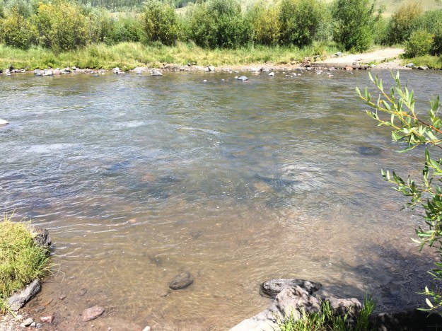
At the conclusion of our journey, we had to actually wade across the Rio Grand River to get to the car, as the trail ended abruptly at the river.  This likely explained why we did not see any other people the entire time we were on the East Ute Creek and Ute Creek trails yesterday and today.

IMG_7309IMG_7310

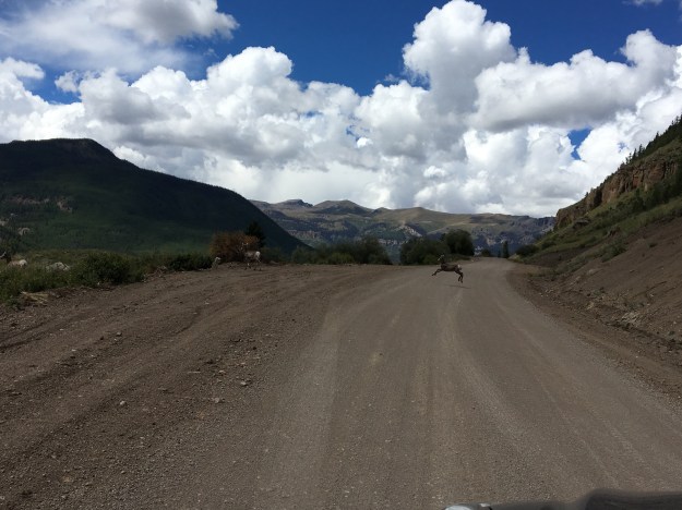
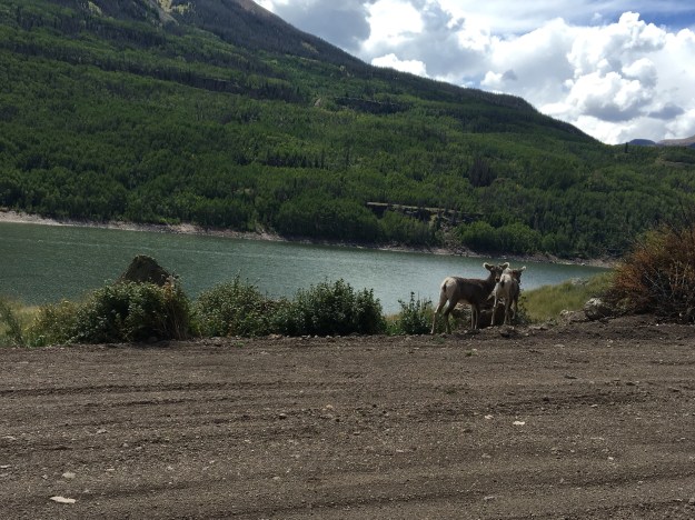
Shortly after leaving the trailhead, I saw what looked like baby mule deer living along the steepest part of the hill.

IMG_7323.jpg

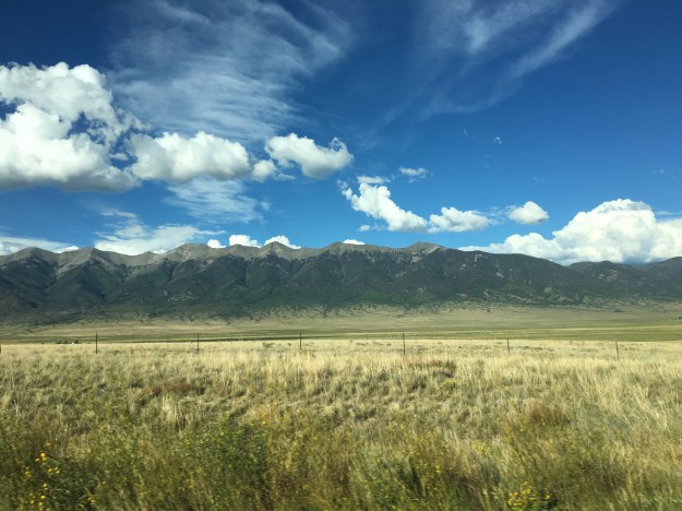
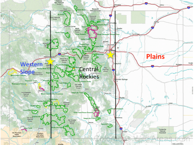
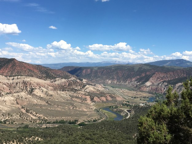
Like the journey to the Wilderness, the journey home took us by some of Colorado’s highest peaks and most stunning mountainous features.  I thought of the “real world” I was gradually re-entering, the life I live and the journey I just took.  It is not important whether we are “conforming” or “rebelling”, because, like life in the woods, it can be thought of as conformist or rebellious depending on perspective.

Those of us that are honest with ourselves, and with those around us, will undoubtedly find ourselves in both situations.  We’ll find ourselves in a place where our choices are the same as those around us, and be suseptable to being labelled “conformists”.  We’ll also, at some point, find ourselves in a place where our choices are not those of the majority, and be met with skepticism, hostility, and possibly even pressure to change.  What matters most, is not fitting into an image we may have of ourselves, whether it be the upstanding citizen, rebel, outcast, or whatever, it is that we have the courage to be all things, depending on our setting, in order to be true to ourselves.

Cycling from Denver to Cheyenne

IMG_6854On the evening of July 3rd, having just finished an exhausting six-day bike ride, including four days of cycling over one hundred miles, my body felt a bit relieved.  I was actually ready to rest, ready to sit in front of a computer again!  Clay, however, told me that I was going to wake up the next morning, realize I was not biking 100+ miles and not know what to do with myself.

The truth ended up being somewhere in the middle.  I could not have pictured cycling at all the next day.  This was literally how I felt.

IMG_6644

The next day, I biked six miles, to and from Union Station from my home.  And, I was perfectly fine with that.

However, I did eventually get antsy, despite two other, closer to home adventures.  By Tuesday July 19th, I posted this picture on Instagram, stating I was bored and wishing to get on my bike and explore again!

IMG_6808

I ride the new RTD A-Line train, which connects downtown Denver with Denver International Airport, roughly three days a week for a gig I am currently working at the airport.  At Central Park Station, one of six intermediate stops between downtown and the airport, this curious piece of potentially symbolic artwork sits atop a pillar.

IMG_6809

Whenever I am on the train, and not trying to sleep for efficiency sake, I see it, and sincerely wonder what its purpose is.  It seems to depict a person running to catch the next train, but headless.  But why headless?  Could it actually be a satire on the futility of the rat race?  Could the artist who created the sculpture have had an alterior motive?  Could he or she have created this sculpture with the secret hope that a few commuters each day would look at this sculpture and be prompted to ask; what am I doing and why am I doing it?  Is this the life I wanted?  Is this the natural state of human condition?  Etc.?

I, however, had other plans, actually for the next Friday, and, they once again involved my 2012 Bianchi Cyclocross bicycle.  The Cheyenne Frontier Days Rodeo was starting, and, I was going to ride my bike there!

The prior evening, I spent the night in Broomfield, after a softball game in Boulder.  So, even before this next 100+ mile bike ride, I was already spending some significant time on my bike again.  Knowing it was going to be hot, we got an early start.  I actually wish we had gotten an earlier start.

BikeRoute_DenvertoCheyenne

A lot of people hear about my bike adventures and immediately sounds perplexed…

Is there a trail there?

Are there safe roads to bike on there?

There’s a lot of trucks on that road.

I would never ride my bike on those roads, you could get killed.

Etc.…

There is some risk, no denying it.  When I was a child, one of my favorite bands, the Offspring, told me “Back up your rules.  Back up your jive.  I’m sick of not living just to stay alive.”  More recently, Drake told me, “Everybody dies, but not everybody lives.”  The truth is that there is the possibility of death doing nearly everything.  People die on the slopes.  People die rafting.  But, people also die commuting to work.  And, due to the health risk factors such as cardiovascular disease and such, sitting around watching television can be deadly!

That being said, I still considered risk when choosing a route, and am still willing to go a few extra miles to reduce my risk.  I am just not willing to miss out on opportunities altogether out of fear.

IMG_6814

The first part of the ride was pleasant, 95th St. from Broomfield to Longmont is a road I knew had bicycle accommodations in the form of bike lanes or wide enough shoulders.

Longmont was a little bit tougher to navigate.  Like many towns, their bike route network was designed primarily with travel within the town in mind.  I stared at their bike map for a good half an hour to figure out the best route through town, but it ended up being a fun route.

IMG_6817

I particularly enjoyed all the sculptures along the Saint Vrain Greenway!

IMG_6818

One thing people miss when they drive along I-25 between Denver and Fort Collins is how many lakes there are in the area.  On the interstate, there are none.  On this route between Longmont and Fort Collins, through Berthoud and Loveland, we actually saw a lot of lakes.

I’d been pondering riding my bike from Denver to Cheyenne for years, even going as far as thinking about some of the details, such as what time of year to go and what route to take.  As soon as I started thinking about routing, there was one segment I knew I was going to do, the combination of Taft Avenue and Shields St. through Loveland and Fort Collins, roughly half a mile west of highway 287.  This straight shot through both towns has a bike lane the entire way, and made navigating through Loveland and Fort Collins was easier than navigating through Longmont.

IMG_6821

This is where I started to feel the heat, which was right around 10:30 or 11:00.  The temperature probably hit 90 sometime while we were in Fort Collins, making me regret having not left even earlier than we did (we departed at about quarter to 7 in the morning).

Also, the wind had a slight easterly component that day.  This made the next two segments of the ride, first from Fort Collins to Wellington, where we stopped for lunch around noon, and then from Wellington to Nunn to reach U.S. highway 85, quite possibly the most challenging segments of the ride.  I had this nagging feeling about entering Weld County.  I do not know why, I just felt as if something bicycle unfriendly would happen to me in this county specifically.  It was mainly just a premonition that bore out to be true, just not in the way I had anticipated.

IMG_6845

Upon entering Weld County, the road we were following switched to newly paved blacktop, while the temperatures had climbed probably into the mid-90s.  This lead to the closest thing to heat exhaustion we would experience during the ride.

IMG_6846

By the time we reached Nunn, we were desperate to get out of the heat for a few minutes and get some water.  Unfortunately, despite the fact that Nunn has a water tower that says “Watch Nunn grow”, I’m 100% sure that my calf muscles were growing faster than Nunn that day.  The only place we could find to fill up our water bottles was the police station/town hall, and the only reason that option was available to us is because we were riding on a weekday (Friday).

IMG_6847

We followed U.S. 85 for the last 30 miles of the ride.  We ended up having to wait out a mid-afternoon thunderstorm near the Colorado-Wyoming border, at the only building within a 10-mile radius.

IMG_6850

The storm was, however, neat, and I felt as if I were storm chasing on my bicycle (even though in real life that would have been a disaster).

We arrived in Cheyenne during rush hour, which was a little nerve racking as this is the only part of the ride where the shoulder on U.S highway 85 disappears, the last couple of miles before entering town.

After 109 miles of riding, we were there, Cheyenne Frontier Days, miraculously with enough energy left to party, parade, and rodeo!

Glenwood Springs: Where Canyon Country Begins

IMG_0014.jpg

When people think of the American West, certain images often come to mind:  the unique natural features of Yellowstone.  Iconic mountains that tower over the nearby landscape, such Rainier and Hood.  The canyons that carve through the American Southwest, creating popular destinations such as the Grand Canyon.

The Grand Canyon is not the only canyon of the American West.  In fact, it is not the only canyon carved out by the Colorado River, the continent’s fifth longest running river.  The river, has its source at Rocky Mountain National Park and snakes through the west carving out  numerous canyons.  In fact, there are some that believe that the canyon in Southern Utah that was flooded when Glen Canyon Dam was built, a couple of hundred miles upstream of the Grand Canyon, was even more scenic than the Grand Canyon itself (some are even looking to remove the dam despite the Wests water needs).

An overly simplified model of Colorado’s geography, is that of the three flavored boxes Neapolitan Ice Cream.  Colorado’s three sections are the Plains, the Central Rockies, and a region generally referred to as the Western Slope.  While the Western Slope is officially defined as anywhere west of the Continental Divide, culturally, we tend to think of it as west of Ski Country, which also happens to coincide with where canyon country begins.

Glenwood_20160725

On the above map, the two yellow stars are Denver, where the Plains end and the Central Rockies begin, and Glenwood Springs, where, traveling west the terrain transitions from tall peaks to canyons, mesas, and plateaus.

The official reason for the trip to Glenwood this year was whitewater rafting, a group trip that I organize every year, with a different destination each time.

This year, the trip was a little bit later in the season, early July, rather than mid-June.  The later date allowed more of the mountain snowpack to melt, particularly this year, as the period around the fourth of July was quite hot across the state.  As a result, the rapids were not nearly as intense as the previous two years.  However, the trip was not without its moments.  This time, everybody stayed in the raft!

As was the case last year and the year prior (this is the third year of my annual trip), we camped.  We selected a somewhat peculiar place to camp this year, on top of the White River Plateau north of town.

IMG_6664

To get to the Plateau, we had to follow a road called Coffee Pot Road, a bumpy road that rose up out of the Colorado River Valley below us and onto the plateau several thousand feet above it.

IMG_6661.jpg

Here is where I fully came to the realization that I was on the border of two of Colorado’s “stripes”.  Looking east from the campground, in clear view are the tallest peaks of the Central Rockies, the Sawatch Range, which includes Mount Evans, Colorado’s tallest peak.

IMG_6715.jpg

A mere mile to the west of our campsite sits Deep Creek Canyon.  I had no idea this canyon existed.  Deep Creek is a tiny creek, carrying very little water at the time we saw it.  Yet, it manages to carve a 2100 foot deep crevice in the landscape in a manner similar to Black Canyon and other Western Canyons.

IMG_6667IMG_6669

What really made this feel like a peculiar place to camp was the range of temperatures we would experience over the course of the weekend.  We spent the middle part of the day in the valley, first rafting in the Colorado River than in town, all at elevations below 6000 feet.  Daytime temperatures soared well into the 90s!  At night, we returned to our campground, above 10,000 feet in elevation, where nighttime temperatures fell into the upper 40s.  If one were looking to experience comfortable temperatures, it would make sense to do the exact opposite, spending the daytime hours at higher elevations where it is cooler and then returning to the valley at night.

IMG_6682

The town of Glenwood Springs is a touristy town.  Everyone around, from the rafting instructors to the bus drivers describe it as such.  However, it is touristy in a different way than some other places I’ve visited.  I didn’t see 50 ice cream shops like I do in South Haven, MI.  I did not see anything like Ripley’s Believe it Not or the other places I see at the Wisconsin Dells.  And, I certainly didn’t see 150 T-shirt shops as I do when I visit Cooperstown.  It seemed like more bars and restaurants than anything else here.  And, of course, one of Glenwood’s other main draws, the hot springs.

IMG_6683

Maybe Glenwood’s tourism industry is simply trying to accommodate a different mix of people than those other places, or maybe they are simply trying to stay true to their own unique identity.  After all, there are a lot of activities in the area, and a lot of reasons for people to visit.

IMG_6680.jpg

Just east of town, is the area known as Glenwood Canyon.  Due to the narrowness of this valley, there are sections of I-70 where the speed limit drops to 50 miles per hour, the westbound lanes are stacked on top of the eastbound lanes, and parts of the highway are tunneled underneath rock that goes right up to the River.

IMG_6684

It is in this canyon, several miles east of town, where Glenwood’s signature hike, Hanging Lake Trail draws so many tourists, that the parking lot is commonly full.  In fact, both Friday and Saturday, highway signage indicated that this lot was full anytime we drove by it.  We were able to get parking spots in the later part of the afternoon, around half past four, after the rafting trip, and lunch in town.

Hanging Lake is a short but challenging trail.  Only 1.2 miles long, it climbs 1200 feet in elevation.  This, both made sense and surprised me at the same time.  Being in a canyon, I knew that any hike in the area would be steep, and this one sure had its steep parts.  What surprised me was, how far up the canyon hanging lake is.

IMG_6691

I had seen pictures of this lake before, and knew the trail was short, I just pictured it being much shorter and much closer to the bottom of the canyon.

The trail was crowded, which should not be surprising, given that the parking lot was still almost completely full when we arrived.  What surprised me was the ethnic diversity of the crowd hiking this trail.  On the way up to hanging lake, which probably took a little over 30 minutes, I heard people speaking all sorts of different languages!  I enjoyed seeing so many different kinds of people enjoying scenery, nature, and, as I speculate, a weekend away from it all.

There is only one area attraction I did not get to, the Glenwood Caverns Adventure Park.  It’s hard to get to everything on a short weekend trip.  I guess there is still a lot more for me to see here in Glenwood, where Westbound travelers leave the high peaks of the Central Rockies and enter the land of deep canyons.